1980s Maps of Allendale Charter Township, Michigan
Explore 6 historic maps of Allendale Charter Township from the 1980s. These maps offer a rare glimpse into what life looked like during the 1980s — showing old roads, neighborhoods, homes, and landmarks that have changed or disappeared over time.
Whether you're researching your family's past, planning a metal detecting trip, or studying how Allendale Charter Township's landscape evolved across the 1980s, these high-resolution maps are a powerful tool for exploring the history of this region.
- Focus on a specific era: All maps on this page are from the 1980s, giving you a focused view of this time period.
- See what’s changed: Compare century-old streets, trails, and buildings to today's modern landscape using overlays and satellite layers.
- Research with precision: Use these maps for genealogy, historical research, land use analysis, or educational projects.
- View, download, or print: Maps are fully viewable online in high resolution, and can be downloaded or printed for your own records.
Start exploring Allendale Charter Township's history through authentic maps from the 1980s. This is your window into the past.
Allendale Charter Township, MI maps
(6)- 1980 Map of Coopersville
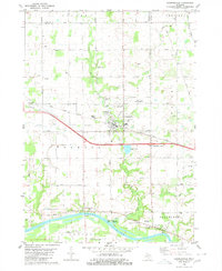 1980 Coopersville1980 Print · USGSThe Grand River valley in the early eighties shows a landscape shaped by both the river's edge and the rail line. Researchers can locate family sites near Coopersville Cemetery, trace the Grand Trunk Western railroad, or find the riverside settlement of Eastmanville.
 - 1982 Map of Muskegon
 1982 Muskegon1982 Print · USGSThe West Michigan shoreline during the early eighties shows a bustling industrial and maritime landscape centered on Muskegon Lake and Grand Haven. Researchers can trace rail history along the Grand Trunk Western or locate local landmarks like Oakwood Cem and Cloverville.
 - 1982 Map of Holland
 1982 Holland1982 Print · USGSThe Lake Michigan coast in the early eighties shows a refined network of Dutch-influenced settlements and lakeside retreats. Trace the rail lines of the Chesapeake and Ohio or find family landmarks near Noordeloos and New Richmond.
 - 1984 Map of Grand Rapids
 1984 Grand Rapids1984 Print · USGSWest Michigan in the mid-eighties shows a thriving metropolitan core surrounded by expansive state recreation areas and river valleys. Genealogists and local historians can trace developments around Grand Rapids, institutional landmarks like Grand Rapids Bible College, and the quiet reaches of Jordan Lake.
 - 1985 Map of Cedar Springs
 1985 Cedar Springs1985 Print · USGSThe northern reaches of the Grand Rapids metro area meet the forests of the Manistee during the mid-eighties. Genealogists and historians can trace the paths of the Grand Trunk Western RR through Sparta or locate rural landmarks near Cedar Springs and Rockford.
 - 1986 Map of Cedar Springs, 1989 Print
 1986 Cedar Springs1989 Print · USGSThe northern suburbs of Grand Rapids meet the Manistee National Forest in the mid-1980s. Genealogists and historians can trace the rail-side growth of Howard City, Rockford, and Greenville along the C & O RR and Flat River.
End of results
Showing maps 1-6 of 6
Top cities near Allendale Charter Township
- Grand Rapids historical maps
- Wyoming historical maps
- Muskegon historical maps
- Holland historical maps
- Byron Township historical maps
- Walker historical maps
See more
Top neighborhoods of Allendale Charter Township
Frequently asked questions
- What are the different types of historical maps available for Allendale Charter Township?
- What is the oldest map of Allendale Charter Township?
- Where can I purchase historical maps of Allendale Charter Township for my home or office?
- Where can I download high-res historical maps of Allendale Charter Township?
- Are there historical topographic maps available for Allendale Charter Township?
- Is there historical aerial imagery available for Allendale Charter Township?
- Where are historical maps of Allendale Charter Township sourced from?