1960s Maps of Richfield Township, Michigan
Explore 6 historic maps of Richfield Township from the 1960s. These maps offer a rare glimpse into what life looked like during the 1960s — showing old roads, neighborhoods, homes, and landmarks that have changed or disappeared over time.
Whether you're researching your family's past, planning a metal detecting trip, or studying how Richfield Township's landscape evolved across the 1960s, these high-resolution maps are a powerful tool for exploring the history of this region.
- Focus on a specific era: All maps on this page are from the 1960s, giving you a focused view of this time period.
- See what’s changed: Compare century-old streets, trails, and buildings to today's modern landscape using overlays and satellite layers.
- Research with precision: Use these maps for genealogy, historical research, land use analysis, or educational projects.
- View, download, or print: Maps are fully viewable online in high resolution, and can be downloaded or printed for your own records.
Start exploring Richfield Township's history through authentic maps from the 1960s. This is your window into the past.
Richfield Township, MI maps
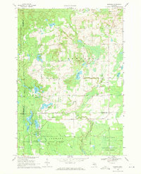
(6)- 1965 Map of St. Helen NW, 1966 Print
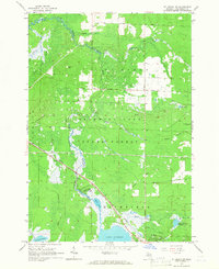 1965 St. Helen NW1966 Print · USGSThe Au Sable River headwaters and the sprawling Au Sable State Forest define this mid-1960s Roscommon County landscape. Genealogists and historians can trace old logging routes like the Old Railroad Grade and locate early settlements such as Geels, Keno, and St Helen.2 unique versions available
 - 1965 Map of St. Helen NE, 1966 Print
 1965 St. Helen NE1966 Print · USGSOgemaw County's transition from timber harvesting to recreational forest is evident in this mid-sixties survey. Researchers can trace historic land use through the Old Railroad Grade, find family sites near Fisk Cem, and locate the Oil Well and Claypit that supported the local economy.2 unique versions available
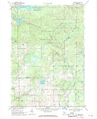
 - 1965 Map of St. Helen, 1966 Print
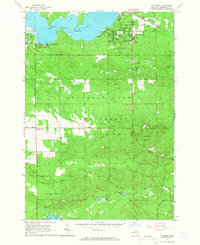 1965 St. Helen1966 Print · USGSThe lakeside community of St. Helen and the surrounding state forest are captured here in the mid-1960s. Researchers can trace the New York Central Railroad corridor and locate local landmarks like Fairview Cem and Artesia Beach.2 unique versions available
 - 1965 Map of Ogemaw Springs, 1966 Print
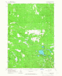
 1965 Ogemaw Springs1966 Print · USGSOgemaw County in the mid-1960s reveals a landscape of state forests, rail lines, and scattered rural landmarks. Genealogists and local historians can locate the Beaver Lake Cem, the Pleasant Hill Sch, and a notable Indian Mound near Ogemaw Springs.2 unique versions available
 - 1969 Map of Edwards, 1971 Print
 1969 Edwards1971 Print · USGSCentral Michigan's lake-studded woodlands are captured here in the late sixties at the intersection of Ogemaw, Roscommon, and Gladwin counties. Genealogists and local historians can trace family-named routes and community landmarks like Edwards Cem, Oak Grove Ch, and the settlement of Edwards.
 - 1969 Map of Butman, 1971 Print
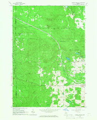
 1969 Butman1971 Print · USGSThe northern Michigan woods at the turn of the 1970s reveal a landscape of timber, water, and early oil exploration. Genealogists and historians can trace the rural community of Butman, locate the Butman Cem, and follow the banks of the Sugar River.
End of results
Showing maps 1-6 of 6
Top cities near Richfield Township
- Saint Helen historical maps
- Butman historical maps
- West Branch historical maps
- Prudenville historical maps
- Edwards historical maps
- Roscommon historical maps
Top neighborhoods of Richfield Township
- Artesia Beach historical maps
- Au Sable River Park historical maps
- Geels historical maps
- Maple Valley historical maps
- Saint Helen historical maps
Frequently asked questions
- What are the different types of historical maps available for Richfield Township?
- What is the oldest map of Richfield Township?
- Where can I purchase historical maps of Richfield Township for my home or office?
- Where can I download high-res historical maps of Richfield Township?
- Are there historical topographic maps available for Richfield Township?
- Is there historical aerial imagery available for Richfield Township?
- Where are historical maps of Richfield Township sourced from?