1940s Maps of Zilwaukee Township, Michigan
Explore 3 historic maps of Zilwaukee Township from the 1940s. These maps offer a rare glimpse into what life looked like during the 1940s — showing old roads, neighborhoods, homes, and landmarks that have changed or disappeared over time.
Whether you're researching your family's past, planning a metal detecting trip, or studying how Zilwaukee Township's landscape evolved across the 1940s, these high-resolution maps are a powerful tool for exploring the history of this region.
- Focus on a specific era: All maps on this page are from the 1940s, giving you a focused view of this time period.
- See what’s changed: Compare century-old streets, trails, and buildings to today's modern landscape using overlays and satellite layers.
- Research with precision: Use these maps for genealogy, historical research, land use analysis, or educational projects.
- View, download, or print: Maps are fully viewable online in high resolution, and can be downloaded or printed for your own records.
Start exploring Zilwaukee Township's history through authentic maps from the 1940s. This is your window into the past.
Zilwaukee Township, MI maps
(3)- 1941 Map of Saginaw, 1958 Print
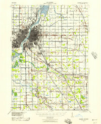 1941 Saginaw1958 Print · USGSThe Saginaw River Valley in the early 1940s reveals a bustling network of river-and-rail industry and rural district schools. Genealogists can trace family landmarks like Frankentrost Sta, Birch Run, and the Crow Island Sch.2 unique versions available
 - 1943 Map of Bay City
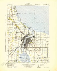 1943 Bay City1943 Print · USGSThe Saginaw River valley and the shores of Saginaw Bay appear here in the midst of the Second World War. Researchers can trace the industrial rail lines of the Pere Marquette or locate vanished local landmarks like Wenona Beach and the Sugar Sch.
 - 1943 Map of Saginaw
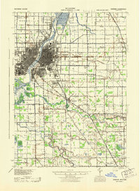 1943 Saginaw1943 Print · USGSSaginaw and its surrounding river valleys are captured here during the wartime era, showing a landscape defined by heavy rail and branching waterways. Genealogists and historians can locate dozens of country schoolhouses like Frankentrost Sch and Popp Sch alongside rail stops at Fosters and Blackmar.
End of results
Showing maps 1-3 of 3
Top cities near Zilwaukee Township
- Saginaw historical maps
- Bay City historical maps
- Kawkawlin historical maps
- City of Frankenmuth historical maps
- Frankenmuth historical maps
- Kochville historical maps
See more
Frequently asked questions
- What are the different types of historical maps available for Zilwaukee Township?
- What is the oldest map of Zilwaukee Township?
- Where can I purchase historical maps of Zilwaukee Township for my home or office?
- Where can I download high-res historical maps of Zilwaukee Township?
- Are there historical topographic maps available for Zilwaukee Township?
- Is there historical aerial imagery available for Zilwaukee Township?
- Where are historical maps of Zilwaukee Township sourced from?