1940s Maps of Saint Clair County, Michigan
Explore 5 historic maps of Saint Clair County from the 1940s. These maps offer a rare glimpse into what life looked like during the 1940s — showing old roads, neighborhoods, homes, and landmarks that have changed or disappeared over time.
Whether you're researching your family's past, planning a metal detecting trip, or studying how Saint Clair County's landscape evolved across the 1940s, these high-resolution maps are a powerful tool for exploring the history of this region.
- Focus on a specific era: All maps on this page are from the 1940s, giving you a focused view of this time period.
- See what’s changed: Compare century-old streets, trails, and buildings to today's modern landscape using overlays and satellite layers.
- Research with precision: Use these maps for genealogy, historical research, land use analysis, or educational projects.
- View, download, or print: Maps are fully viewable online in high resolution, and can be downloaded or printed for your own records.
Start exploring Saint Clair County's history through authentic maps from the 1940s. This is your window into the past.
Saint Clair County, MI maps
(5)- 1942 Map of Rattle Run
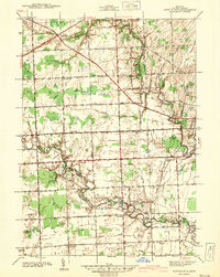 1942 Rattle Run1942 Print · USGSSt. Clair County's rural townships are captured here just before the mid-century, showing a landscape of river-bend mills and country schoolhouses. Genealogists can locate family landmarks like Bell River Mills, Salem Ch, and the Tritten Sch grounds.2 unique versions available
 - 1944 Map of Memphis
 1944 Memphis1944 Print · USGSSoutheast Michigan farm country is documented here in the 1940s, showing the early crossroads and river-bound settlements of St. Clair and Macomb counties. Genealogists can locate family landmarks like Pound Hill Sch, the village of Riley Center, and the Grand Trunk Western rail line.2 unique versions available
 - 1945 Map of Allenton
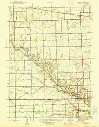
 1945 Allenton1945 Print · USGSSt. Clair County's farming heartland is captured here in the mid-1940s, showing a landscape of tight-knit rural communities and school districts. Genealogists can trace family locations near Allenton, Scotch Settlement, and several country schools like Gould Sch and Stoddard Sch.2 unique versions available
 - 1949 Map of Port Huron
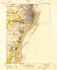 1949 Port Huron1949 Print · USGSPort Huron and the St. Clair River border come to life in the late 1940s, showing a bustling international port and rail hub. Genealogists and local historians can trace city neighborhoods near Roosevelt Sch, the industrial waterfront of Marysville, and the sprawling Woodland Cem.
 - 1949 Map of St. Clair Flats
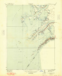 1949 St. Clair Flats1949 Print · USGSThe St. Clair River delta is captured here in the late thirties, showing a labyrinth of marshlands and island settlements. Trace family property and local landmarks along South Channel Rd or explore the early layout of Riverside and The Old Club.2 unique versions available
End of results
Showing maps 1-5 of 5
Top cities of Saint Clair County
- Port Huron historical maps
- Marysville historical maps
- Saint Clair historical maps
- Columbus Township historical maps
- Algonac historical maps
- Marine City historical maps
See more
Frequently asked questions
- What are the different types of historical maps available for Saint Clair County?
- What is the oldest map of Saint Clair County?
- Where can I purchase historical maps of Saint Clair County for my home or office?
- Where can I download high-res historical maps of Saint Clair County?
- Are there historical topographic maps available for Saint Clair County?
- Is there historical aerial imagery available for Saint Clair County?
- Where are historical maps of Saint Clair County sourced from?