1960s Maps of Saint Clair County, Michigan
Explore 23 historic maps of Saint Clair County from the 1960s. These maps offer a rare glimpse into what life looked like during the 1960s — showing old roads, neighborhoods, homes, and landmarks that have changed or disappeared over time.
Whether you're researching your family's past, planning a metal detecting trip, or studying how Saint Clair County's landscape evolved across the 1960s, these high-resolution maps are a powerful tool for exploring the history of this region.
- Focus on a specific era: All maps on this page are from the 1960s, giving you a focused view of this time period.
- See what’s changed: Compare century-old streets, trails, and buildings to today's modern landscape using overlays and satellite layers.
- Research with precision: Use these maps for genealogy, historical research, land use analysis, or educational projects.
- View, download, or print: Maps are fully viewable online in high resolution, and can be downloaded or printed for your own records.
Start exploring Saint Clair County's history through authentic maps from the 1960s. This is your window into the past.
Saint Clair County, MI maps
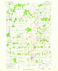
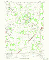
(23)- 1961 Map of Brown City, 1963 Print
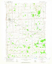 1961 Brown City1963 Print · USGSThe rural borderlands of Sanilac, Lapeer, and St. Clair counties come alive in this early 1960s survey of the Michigan thumb's farming heartland. Trace the paths of the Chesapeake and Ohio railroad through Brown City or find ancestral sites like Valley Center Cem and Odelville Sch.2 unique versions available
 - 1961 Map of Ruby, 1963 Print
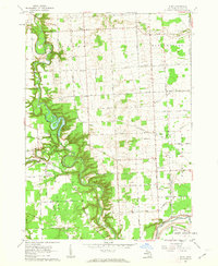 1961 Ruby1963 Print · USGSSt. Clair County in the early sixties shows a landscape of winding river valleys and rural rail corridors. Genealogists and historians can trace family locations near Ruby and Blaine, or locate old landmarks like Central Ch and the Kinney Cem.3 unique versions available
 - 1961 Map of Roseburg, 1963 Print
 1961 Roseburg1963 Print · USGSSanilac and St. Clair counties are shown in the early sixties, featuring a landscape defined by traditional township grids and rural schoolhouses. Researchers can locate family landmarks like Fremont Cem, the Roseburg Sch, and the quiet crossroads of Livergood.2 unique versions available
 - 1961 Map of Avoca, 1963 Print
 1961 Avoca1963 Print · USGSIn the early 1960s, this pocket of St. Clair County was a landscape of rail-fed hamlets and winding waterways. Researchers can trace the lineage of rural communities at Avoca, Fargo, and Abbottsford, alongside country landmarks like Emanuel Ch and Allen Sch.2 unique versions available
 - 1961 Map of Lakeport, 1963 Print
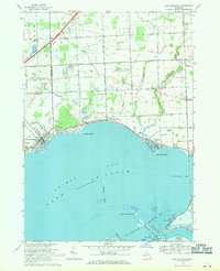
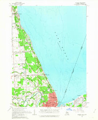 1961 Lakeport1963 Print · USGSCoastal St. Clair County meets the Ontario shoreline in the early sixties, documenting the bustling international border along the St Clair River. Researchers can trace the layout of Port Huron, locate the historic Mt Hope Cemetery, and find the early footprint of Baker Airport.2 unique versions available
 - 1961 Map of Jeddo, 1963 Print
 1961 Jeddo1963 Print · USGSThe Lake Huron shoreline and the rural interior of Sanilac and St. Clair counties are captured here in the early sixties. Genealogists and local historians can locate early schools and churches like Cook School and Bethel Church, or trace the Chesapeake and Ohio rail line.2 unique versions available
 - 1961 Map of Brockway, 1963 Print
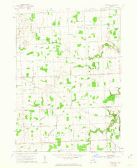
 1961 Brockway1963 Print · USGSSt. Clair County's rural townships are captured here in the early 1960s as a network of agricultural drains and small rail-side settlements. Genealogists can trace property near Yale, find Moore Cem, or locate family landmarks like Cole Ch and Meharg Drain.2 unique versions available
 - 1961 Map of Yale, 1963 Print
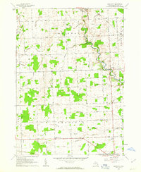
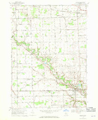
 1961 Yale1963 Print · USGSThe agricultural landscape of St. Clair and Sanilac Counties is captured here in the early sixties, centered on the railroad hub of Yale. Genealogists can locate rural landmarks like Sacred Heart Cem, McFadden Cem, and North School.
 - 1961 Map of Capac, 1963 Print
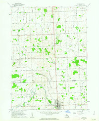
 1961 Capac1963 Print · USGSAgricultural life in St. Clair County during the early sixties centers on the village of Capac and its extensive drainage network. Genealogists can trace local landmarks like Pine Hill Cem, the Lynn Corner Sch, and the Grand Trunk rail line.2 unique versions available
 - 1961 Map of Detroit, 1973 Print
 1961 Detroit1973 Print · USGSThe international border between Michigan and Ontario was a bustling industrial corridor in the early sixties. Researchers can trace the transit networks and riverfront infrastructure connecting Detroit to Windsor via the Detroit-Windsor Tunnel and major air hubs like Willow Run Airport.2 unique versions available
 - 1965 Map of Detroit
 1965 Detroit1965 Print · USGSThe industrial corridor between Michigan and Ontario is captured here at mid-century, showing the dense rail and river networks of the Great Lakes. Local historians can trace the paths of the Grand Trunk Western RR and locate key landmarks like Selfridge Air Force Base and Grosse Ile.
 - 1968 Map of Allenton, 1970 Print
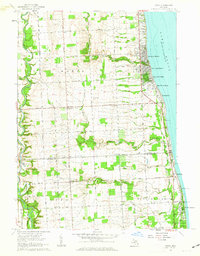
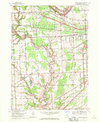
 1968 Allenton1970 Print · USGSThe rural townships of St. Clair County are captured here in the late sixties, showing a landscape of small villages and established farmsteads. Researchers can trace family history through the Scotch Settlement Cem, the West Berlin Ch, and the active Berlin Oil Field.
 - 1968 Map of Goodells, 1970 Print
 1968 Goodells1970 Print · USGSSt. Clair County's rural townships in the late sixties remain centered on the rail-and-river economy of the Grand Trunk Western. Genealogists can trace family roots through the Kenockee Cem, the Lambs Sch, and the Goodells Mission.2 unique versions available
 - 1968 Map of Smiths Creek, 1970 Print
 1968 Smiths Creek1970 Print · USGSSt. Clair County in the late sixties shows a landscape of growing townships and critical infrastructure along the BLACK RIVER. Researchers can trace local heritage through sites like St Marys Cem, the community at Smiths Creek, and the Sparlingville Sch grounds.2 unique versions available
 - 1968 Map of Memphis, 1970 Print
 1968 Memphis1970 Print · USGSCrossing the St. Clair and Macomb county line in the late sixties, this area shows a landscape defined by the winding Belle River and the Grand Trunk Western rail line. Genealogists can locate family landmarks such as the Memphis Cem, All Saints Ch, and the Foley Sch Sparling.
 - 1968 Map of St. Clair, 1971 Print
 1968 St. Clair1971 Print · USGSThe international border along the St Clair River is shown here in the late sixties, capturing the distinct industrial and residential characters of Michigan and Ontario. Genealogists can trace family landmarks like St Marys Cem, Eddy Sch, and the riverside settlement at Hawthorne.2 unique versions available
 - 1968 Map of New Baltimore, 1971 Print
 1968 New Baltimore1971 Print · USGSNorthern Lake St. Clair coastal life is captured here in the late sixties as residential expansion meets industrial utility. Genealogists and local historians can locate Sacred Heart Cem, the Motor City Drag Strip, and Fair Haven Sch.2 unique versions available
 - 1968 Map of Port Huron, 1971 Print
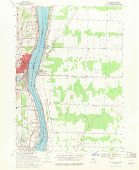
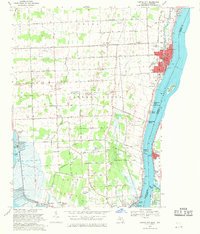
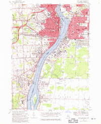 1968 Port Huron1971 Print · USGSThe international border along the St. Clair River thrived in the late sixties as a hub of industry and transport. Genealogists and historians can trace the neighborhoods of Sarnia and Port Huron, locating family landmarks like Riverlawn Cem and St Stephen Sch.3 unique versions available
 - 1968 Map of Rattle Run, 1971 Print
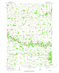
 1968 Rattle Run1971 Print · USGSSt. Clair County in the late sixties shows a transition from traditional riverside milling to a complex landscape of oil fields and gas storage. Researchers can trace family roots through St Marys Cem or locate the historic Belle River Mills and Baird.
 - 1968 Map of Algonac, 1971 Print
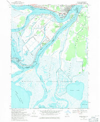 1968 Algonac1971 Print · USGSThe St. Clair River delta is shown in detail during the late sixties, a time when island life revolved around the ferry crossings and international waterways. Researchers can trace family-owned parcels and local landmarks like Sans Souci, St Mark Ch, and the Harsens Island Sch.3 unique versions available
 - 1968 Map of St. Clair Flats, 1971 Print
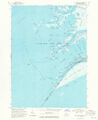 1968 St. Clair Flats1971 Print · USGSThe St. Clair River delta is captured here in the late sixties, showing the complex borderlands between Michigan and Ontario. Genealogists and local historians can trace the unique water-based geography of Harsens Island, Riverside, and the Walpole Island Indian Reserve.2 unique versions available
 - 1968 Map of Marine City, 1971 Print
 1968 Marine City1971 Print · USGSThe St. Clair River shoreline in the late sixties reveals a busy maritime and industrial landscape at the international border. Genealogists and historians can trace family-named sites like Roberts Landing or locate landmarks such as the Holy Cross Cem and the Marine City Airport.4 unique versions available
 - 1968 Map of Adair, 1971 Print
 1968 Adair1971 Print · USGSThe rural landscapes of St. Clair and Macomb counties come alive in this late-sixties study of the area between the Belle and Puttygut rivers. Genealogists can trace family footprints through numerous cemeteries like Kittridge Cem and vanished landmarks in Muttonville and Snyderville.3 unique versions available
End of results
Showing maps 1-23 of 23
Top cities of Saint Clair County
- Port Huron historical maps
- Marysville historical maps
- Saint Clair historical maps
- Columbus Township historical maps
- Algonac historical maps
- Marine City historical maps
See more
Frequently asked questions
- What are the different types of historical maps available for Saint Clair County?
- What is the oldest map of Saint Clair County?
- Where can I purchase historical maps of Saint Clair County for my home or office?
- Where can I download high-res historical maps of Saint Clair County?
- Are there historical topographic maps available for Saint Clair County?
- Is there historical aerial imagery available for Saint Clair County?
- Where are historical maps of Saint Clair County sourced from?