1990s Maps of Saint Clair County, Michigan
Explore 8 historic maps of Saint Clair County from the 1990s. These maps offer a rare glimpse into what life looked like during the 1990s — showing old roads, neighborhoods, homes, and landmarks that have changed or disappeared over time.
Whether you're researching your family's past, planning a metal detecting trip, or studying how Saint Clair County's landscape evolved across the 1990s, these high-resolution maps are a powerful tool for exploring the history of this region.
- Focus on a specific era: All maps on this page are from the 1990s, giving you a focused view of this time period.
- See what’s changed: Compare century-old streets, trails, and buildings to today's modern landscape using overlays and satellite layers.
- Research with precision: Use these maps for genealogy, historical research, land use analysis, or educational projects.
- View, download, or print: Maps are fully viewable online in high resolution, and can be downloaded or printed for your own records.
Start exploring Saint Clair County's history through authentic maps from the 1990s. This is your window into the past.
Saint Clair County, MI maps
(8)- 1991 Map of Rattle Run
 1991 Rattle Run1991 Print · USGSThe rural stretches of St. Clair County are captured here in the early nineties as traditional farming met a growing energy infrastructure. Researchers can trace family roots at Bowman Cem, locate the site of Belle River Mills, or map the extent of the Adair Oil Field.
 - 1991 Map of Adair
 1991 Adair1991 Print · USGSAgricultural life meets the energy industry in St. Clair County during the early nineties, where river valleys are dotted with old family-named drains and oil fields. Genealogists can locate legacy sites like St Michaels Cem, St Peter Sch, and the quiet crossroads of Snyderville.
 - 1991 Map of St. Clair
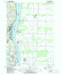 1991 St. Clair1991 Print · USGSThe international border along the St. Clair River was a hub of shared waterway activity in the early 1990s. Researchers can trace the layout of St Clair and Hawthorne, alongside local landmarks like St Marys Cem and Rose Hill Cem.
 - 1991 Map of Smiths Creek
 1991 Smiths Creek1991 Print · USGSSt. Clair County's mix of rural townships and expanding aviation infrastructure is captured here in the early nineties. Researchers can trace family sites like St Marys Cem and Caswell Cem or explore the corridor between Smiths Creek and the Port Huron State Game Area.
 - 1991 Map of Goodells
 1991 Goodells1991 Print · USGSSt. Clair County is shown during a period of rural stability in the early 1990s, where traditional townships meet modern transportation corridors. Researchers can trace the layout of small communities like Goodells and Wales Center, or locate specific sites such as Maryglade Seminary and Our Lady of Mt Carmel Cem.
 - 1991 Map of Memphis
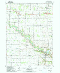 1991 Memphis1991 Print · USGSThe St. Clair and Macomb county line meets at Memphis in the late eighties, showing a landscape of small airstrips and drainage networks. Genealogists can locate family landmarks like the Farrell Sch, Mt Carmel Ch, and the Memphis Cem.
 - 1991 Map of Allenton
 1991 Allenton1991 Print · USGSThe rural borderlands of St. Clair County are captured here in the early nineties, showing a landscape of established farms and quiet settlements. Local historians can locate Scotch Settlement, St Johns Ch, and the winding course of the Belle River.
 - 1991 Map of Port Huron, 1992 Print
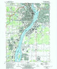 1991 Port Huron1992 Print · USGSThe international border at the St Clair River is captured here during a period of steady industrial and civic growth. Genealogists and historians can trace neighborhood developments near Woodlawn Cem or locate local landmarks like the St Clair Tunnel and Mercy Hospital.
End of results
Showing maps 1-8 of 8
Top cities of Saint Clair County
- Port Huron historical maps
- Marysville historical maps
- Saint Clair historical maps
- Columbus Township historical maps
- Algonac historical maps
- Marine City historical maps
See more
Frequently asked questions
- What are the different types of historical maps available for Saint Clair County?
- What is the oldest map of Saint Clair County?
- Where can I purchase historical maps of Saint Clair County for my home or office?
- Where can I download high-res historical maps of Saint Clair County?
- Are there historical topographic maps available for Saint Clair County?
- Is there historical aerial imagery available for Saint Clair County?
- Where are historical maps of Saint Clair County sourced from?