1970s Maps of Saint Joseph County, Michigan
Explore 4 historic maps of Saint Joseph County from the 1970s. These maps offer a rare glimpse into what life looked like during the 1970s — showing old roads, neighborhoods, homes, and landmarks that have changed or disappeared over time.
Whether you're researching your family's past, planning a metal detecting trip, or studying how Saint Joseph County's landscape evolved across the 1970s, these high-resolution maps are a powerful tool for exploring the history of this region.
- Focus on a specific era: All maps on this page are from the 1970s, giving you a focused view of this time period.
- See what’s changed: Compare century-old streets, trails, and buildings to today's modern landscape using overlays and satellite layers.
- Research with precision: Use these maps for genealogy, historical research, land use analysis, or educational projects.
- View, download, or print: Maps are fully viewable online in high resolution, and can be downloaded or printed for your own records.
Start exploring Saint Joseph County's history through authentic maps from the 1970s. This is your window into the past.
Saint Joseph County, MI maps
(4)- 1972 Map of Three Rivers East, 1974 Print
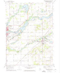 1972 Three Rivers East1974 Print · USGSSt. Joseph County in the early seventies shows a landscape where historic river routes meet the modern rail-and-road network. Researchers can trace family sites at South Park Cem or locate industrial landmarks like the Langley Covered Bridge and Sturgis Dam.2 unique versions available
 - 1972 Map of Klinger Lake, 1974 Print
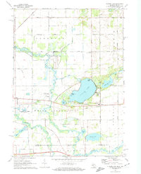 1972 Klinger Lake1974 Print · USGSSouthern Michigan lake life and rural landscapes meet at the Indiana border in the early seventies. Genealogists and local historians can trace the lakeside communities of Breezy Beach, rural landmarks like Calhoun Cem, and the path of the Penn Central railroad.2 unique versions available
 - 1972 Map of Three Rivers West, 1974 Print
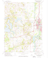 1972 Three Rivers West1974 Print · USGSThe confluence of three major rivers and a dense network of glacial lakes define this St. Joseph County landscape in the early seventies. Genealogists and local researchers can trace family landmarks like Flatbush Cem, Dutch Settlement, and the Lake Section Community School.2 unique versions available
 - 1972 Map of Constantine, 1974 Print
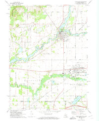 1972 Constantine1974 Print · USGSCrossing the Michigan and Indiana border in the early 1970s, this area shows a landscape shaped by the St Joseph River and the Penn Central railroad. Genealogists and historians can locate several rural landmarks including Stengle Cem, Brick Chapel, and the community of Vistula.
End of results
Showing maps 1-4 of 4
Top cities of Saint Joseph County
Frequently asked questions
- What are the different types of historical maps available for Saint Joseph County?
- What is the oldest map of Saint Joseph County?
- Where can I purchase historical maps of Saint Joseph County for my home or office?
- Where can I download high-res historical maps of Saint Joseph County?
- Are there historical topographic maps available for Saint Joseph County?
- Is there historical aerial imagery available for Saint Joseph County?
- Where are historical maps of Saint Joseph County sourced from?