1960s Maps of Saint Joseph County, Michigan
Explore 8 historic maps of Saint Joseph County from the 1960s. These maps offer a rare glimpse into what life looked like during the 1960s — showing old roads, neighborhoods, homes, and landmarks that have changed or disappeared over time.
Whether you're researching your family's past, planning a metal detecting trip, or studying how Saint Joseph County's landscape evolved across the 1960s, these high-resolution maps are a powerful tool for exploring the history of this region.
- Focus on a specific era: All maps on this page are from the 1960s, giving you a focused view of this time period.
- See what’s changed: Compare century-old streets, trails, and buildings to today's modern landscape using overlays and satellite layers.
- Research with precision: Use these maps for genealogy, historical research, land use analysis, or educational projects.
- View, download, or print: Maps are fully viewable online in high resolution, and can be downloaded or printed for your own records.
Start exploring Saint Joseph County's history through authentic maps from the 1960s. This is your window into the past.
Saint Joseph County, MI maps
(8)- 1961 Map of Grand Rapids
 1961 Grand Rapids1961 Print · USGSSouthern Michigan at the dawn of the 1960s reveals a region shaped by major river systems and a robust rail network. Trace mid-century industrial growth and land use from Grand Rapids to the Fort Custer Military Reservation and Gun Lake.
 - 1961 Map of Sturgis, 1962 Print
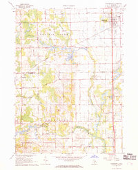
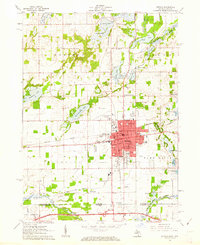 1961 Sturgis1962 Print · USGSSturgis and the Michigan-Indiana border are captured here at a moment of mid-century growth. Genealogists and historians can trace neighborhood schools like Holy Angels Sch, old burial grounds at Tobey Cem, and the path of the New York Central railroad.2 unique versions available
 - 1961 Map of Nottawa, 1962 Print
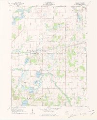 1961 Nottawa1962 Print · USGSSt. Joseph County at the start of the 1960s is a landscape of glacial lakes and intersecting rail lines. Researchers can trace the routes of the New York Central railroad and locate local landmarks like the Community Sch and Nottawa Cem.3 unique versions available
 - 1961 Map of Colon, 1962 Print
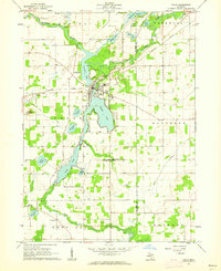 1961 Colon1962 Print · USGSSt. Joseph County at the start of the 1960s reveals a landscape of interconnected glacial lakes and small agricultural hubs. Researchers can trace family roots at Lakeside Cem, locate the Mennonite Ch, or follow the New York Central rail line.2 unique versions available
 - 1961 Map of Burr Oak, 1962 Print
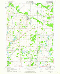 1961 Burr Oak1962 Print · USGSThe Michigan-Indiana borderlands are captured here in the early sixties, showing the agricultural and rail-oriented life of the region. Researchers can locate many family-history sites like Dutch Settlement Cem, Burr Oak, and the Fawn River Sch.2 unique versions available
 - 1962 Map of Grand Rapids
 1962 Grand Rapids1962 Print · USGSMid-century Southern Michigan is mapped here at a time of massive growth, showing the expanding urban footprints of Grand Rapids and Lansing. Researchers can trace the legacy of the Grand Trunk Western RR, find historic boundaries of the Fort Custer Military Reservation, or locate sporting camps around Gun Lake.2 unique versions available
 - 1967 Map of Schoolcraft, 1969 Print
 1967 Schoolcraft1969 Print · USGSSouthwest Michigan's agricultural heartland is documented here in the late 1960s, showing the intersection of rail and rural life. Genealogists can locate family-named routes and community landmarks like Upper Flatbush Cem, Edwards Corners, and the Grange Hall.3 unique versions available
 - 1967 Map of Vicksburg, 1969 Print
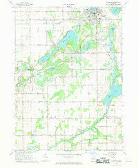 1967 Vicksburg1969 Print · USGSThe village of Vicksburg and the winding Portage River valley are captured here in the late sixties as agricultural and industrial life intersected. Genealogists can locate family sites like Parkville Cem, Scott Cem, and the West Mendon Ch.3 unique versions available
End of results
Showing maps 1-8 of 8
Top cities of Saint Joseph County
Frequently asked questions
- What are the different types of historical maps available for Saint Joseph County?
- What is the oldest map of Saint Joseph County?
- Where can I purchase historical maps of Saint Joseph County for my home or office?
- Where can I download high-res historical maps of Saint Joseph County?
- Are there historical topographic maps available for Saint Joseph County?
- Is there historical aerial imagery available for Saint Joseph County?
- Where are historical maps of Saint Joseph County sourced from?