Old Maps of Schoolcraft County, Michigan
Explore 281 old maps of Schoolcraft County, spanning from 1931 to today. These high-resolution historic maps reveal how streets, neighborhoods, landmarks, and natural features evolved over time — perfect for genealogy, metal detecting, research, and local history exploration.
What you can do with these maps:
- See how Schoolcraft County changed over time: Compare historical maps to modern-day views to trace roads, homesites, rail lines & more.
- View detailed metadata: Each map includes creators, publishers, year, scale, and archive source.
- Overlay maps with satellite & LiDAR: Visualize the past alongside modern tools to explore terrain & human change.
- Trusted historical sources: Maps sourced from the USGS, Library of Congress, and other archives.
- Access maps your way: View online, download high-res files, or order prints for personal or research use.
Start exploring old maps of Schoolcraft County to uncover forgotten places, hidden landmarks, and the deep history beneath your feet.
Schoolcraft County, MI maps
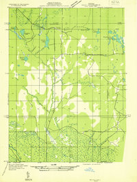
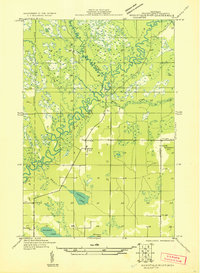
(281)- 1931 Map of Cooks NE
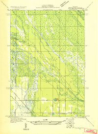
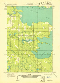
 1931 Cooks NE1931 Print · USGSCoastal Schoolcraft County comes alive in this early 1930s survey of the northern Lake Michigan shoreline. Genealogists and local historians can trace the rail lines of the Manistique Ry and locate family landmarks like Heights Sch and Dufour.
 - 1931 Map of Seney SW
 1931 Seney SW1931 Print · USGSUpper Peninsula wetlands and rail corridors are preserved in this early 1930s survey of Schoolcraft County. Genealogists and historians can trace the foundations of Seney and Germfask along the Manistique River and the Duluth South Shore and Atlantic railroad.
 - 1931 Map of Seney NW
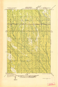
 1931 Seney NW1931 Print · USGSUpper Peninsula wetlands and timberlands are captured here in the early 1930s as State Highway 77 began to define regional travel. Researchers can trace the complex headwaters of the Tahquamenon Lakes and the isolated settlement at Lavender Corner.2 unique versions available
 - 1931 Map of Steuben SE
 1931 Steuben SE1931 Print · USGSUpper Peninsula timberlands and wetlands are surveyed here in the early thirties. Genealogists and local researchers can trace the rail stops and rural schools of Schoolcraft County, from Hiawatha Sta to the Maple Grove Sch near Indian Lake.
 - 1931 Map of Manistique River NE
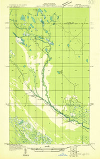
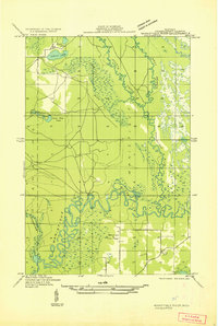
 1931 Manistique River NE1931 Print · USGSSchoolcraft County’s hydrologic network is captured in the early 1930s as the U.S. Army Air Corps began utilizing aerial photography for land surveys. This sheet allows you to trace the intricate meanders of the Manistique River and Driggs River through Doyle and across vast Marsh lands.
 - 1931 Map of Steuben SW
 1931 Steuben SW1931 Print · USGSThe Upper Peninsula wilderness in the early 1930s is documented here through a dense network of glacial lakes and river systems. Historians and outdoor researchers can trace the old water routes of the Indian River and locate landmarks like Thunder Lake and Frankes Lake.
 - 1931 Map of Driggs Lake NE
 1931 Driggs Lake NE1931 Print · USGSThe Upper Peninsula wilderness at the start of the 1930s is documented here through a network of lakes and winding river bends. Trace the early trails and water routes used by foresters and hunters, from the Fox River to the distinctive Little Devils Elbow.2 unique versions available
 - 1931 Map of Steuben NE
 1931 Steuben NE1931 Print · USGSSchoolcraft County in the early thirties reveals a landscape of dense forests and emerging infrastructure within the Hiawatha National Forest Boundary. Researchers can trace the old Manistique and Lake Superior rail line to the Smith Creek Station or locate the rural Hiawatha School No 2.
 - 1931 Map of Seul Choix Point NE
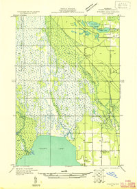
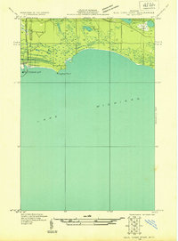 1931 Seul Choix Point NE1931 Print · USGSThe Upper Peninsula coast of Lake Michigan in the early 1930s is defined here by its maritime infrastructure and vast wetlands. Researchers can trace the industrial footprint of Inland Harbor, the navigation at Port Inland Light, and secluded water bodies like Batty Doe Lake.2 unique versions available
 - 1931 Map of Cooks NW
 1931 Cooks NW1931 Print · USGSThe Upper Peninsula wilderness around the Delta and Schoolcraft county line comes into focus in the early 1930s. Genealogists and local historians can trace rural life through the Cooks Sch, the Seventh Day Adventist Sch, and the rail stops of Cooks and Elkhorn.
 - 1931 Map of Shingleton SW
 1931 Shingleton SW1931 Print · USGSThe Upper Peninsula timber and rail landscape at Shingleton comes alive in the early 1930s. Genealogists and historians can trace the intersection of the Duluth South Shore and Atlantic railroad and landmarks like Lilley Lake or Boot Lake.
 - 1931 Map of Seul Choix Point NW
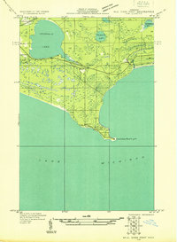 1931 Seul Choix Point NW1931 Print · USGSUpper Peninsula lakefront life is documented here in the early 1930s as the shoreline meets the northern woods. Genealogy researchers can locate the isolated Seul Choix School and Seul Choix Point Light or trace the early rail path of the Minn St Paul and Sault Ste Marie.
 - 1931 Map of Steuben NW
 1931 Steuben NW1931 Print · USGSThe Upper Peninsula wilderness in the early 1930s is defined here by its intricate network of lakes and the essential Manistique and Lake Superior railroad. You can trace the development of the Steuben settlement or locate historic camps like Jack Pine Lodge and the Woods Club along the Indian River.
 - 1931 Map of Manistique River SE
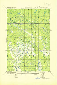
 1931 Manistique River SE1931 Print · USGSThe northern Michigan wilderness of the early 1930s is revealed here through its complex river systems and isolated pioneer outposts. Genealogists can locate rural education centers like the Swede Settlement Sch and Wood Sch among the bends of the Manistique River.
 - 1931 Map of Manistique River NW
 1931 Manistique River NW1931 Print · USGSUpper Peninsula wetlands dominate this Depression-era wilderness survey in Schoolcraft County. You can trace the intricate meanders of the West Branch Manistique River and its tributaries like Stutts Creek and Hickey Creek.
 - 1931 Map of Blaney SW
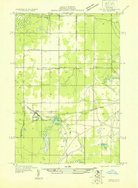
 1931 Blaney SW1931 Print · USGSThe Upper Peninsula timber and rail landscape comes alive in this early 1930s survey of the Schoolcraft County interior. Researchers can trace the industrial footprint of the Lumber Co railroad, the Stone Quarry at Calaspar, and the New Blaney Fire Tower.
 - 1931 Map of Seney SE
 1931 Seney SE1931 Print · USGSThe Upper Peninsula lake country at the start of the 1930s reveals a wilderness defined by its massive waterways and isolated settlements. Genealogists and researchers can trace the rail-and-road corridor of State Highway No 28 and the D S S and A near the Smithers Sch.
 - 1931 Map of Shingleton NE
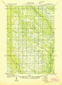
 1931 Shingleton NE1931 Print · USGSThe Alger and Schoolcraft county line in the early 1930s shows a landscape of deep marshes and glacial waters. Trace the path of the L S and Ishpeming railroad or locate the Buck Hill Fire Tower overlooking Spider Lake and the Creighton River.
 - 1931 Map of Driggs Lake NW
 1931 Driggs Lake NW1931 Print · USGSUpper Peninsula wetlands and glacial lakes are documented in the early 1930s as aerial photography began to transform modern mapping. Researchers can trace the original courses of the Driggs River and Little Fox River or locate remote landmarks like Nevins Lake and Mahoney Creek.2 unique versions available
 - 1931 Map of Skeels Lake NE
 1931 Skeels Lake NE1931 Print · USGSThe Upper Peninsula wilderness of the early thirties is captured here as a labyrinth of glacial waters. Researchers can trace the winding Indian River and locate remote landmarks like Hill Tower, Skeels Lake, and Straits Lake.
 - 1931 Map of Blaney NE
 1931 Blaney NE1931 Print · USGSMackinac County’s interior lake country is captured in the early 1930s, showing a wild landscape of timber and wetlands across the Upper Peninsula. Researchers can trace the sprawling bounds of Cranberry Marsh and the undisturbed shorelines of Manistique Lake and Whitefish Lake.
 - 1931 Map of Shingleton SE
 1931 Shingleton SE1931 Print · USGSSchoolcraft County in the early 1930s shows a landscape of expansive wetlands being crossed by new industrial infrastructure. Researchers can trace the path of the Duluth South Shore and Atlantic railroad and find localized points like Creighton and Hickey Creek.
 - 1931 Map of Munising SE
 1931 Munising SE1931 Print · USGSThe Michigan Upper Peninsula was a junction of major timber and freight rails in the 1930s. Genealogists and rail historians can trace the paths of the Duluth South Shore and Atlantic and old stops like Evelyn and Doty.
 - 1931 Map of Manistique River SW
 1931 Manistique River SW1931 Print · USGSSchoolcraft County in the early 1930s is defined by the winding Manistique River and its intricate marshland tributaries. Genealogists and local historians can trace rural landmarks like the Brick Sch and the Manistique Fire Tower.
 - 1931 Map of Driggs Lake SW
 1931 Driggs Lake SW1931 Print · USGSUpper Peninsula wetlands and rail infrastructure are captured here in the early 1930s, showing the intersection of transport and terrain. Trace the early corridor of the Duluth South Shore and Atlantic railroad and the settlement of Walsh near the Driggs River.
Showing maps 1-25 of 281
Top cities of Schoolcraft County
Frequently asked questions
- What are the different types of historical maps available for Schoolcraft County?
- What is the oldest map of Schoolcraft County?
- Where can I purchase historical maps of Schoolcraft County for my home or office?
- Where can I download high-res historical maps of Schoolcraft County?
- Are there historical topographic maps available for Schoolcraft County?
- Is there historical aerial imagery available for Schoolcraft County?
- Where are historical maps of Schoolcraft County sourced from?