
1931 Map of Cooks NE
USGS Topo · Published 1931About this map
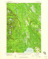
Indian Lake and the northern shoreline of Lake Michigan define this 1931 survey of Schoolcraft County, Michigan. The landscape is a study in early 20th-century coastal development and natural resource management, anchored by the industrial presence of Manistique and the settlement of Thompson. A notable concentration of shoreline landmarks includes Hoveys Beach, Harrison Beach, and Minors Beach, indicating the area's burgeoning role as a recreational destination.
Find a feature on this map
26 named features on this map. Tap any name to fly to it.
Don’t see what you’re looking for? This feature index may not catch every label — zoom into the map to look around manually.
Map Details
Editions of this 1931 Cooks NE Map
This is the sole edition of this map. No revisions or reprints were ever made.
Other maps of this area

1931 · Steuben SE
USGS Topo · 1:31,680

1931 · Steuben SW
USGS Topo · 1:31,680

1931 · Cooks NW
USGS Topo · 1:31,680

1931 · Manistique River SW
USGS Topo · 1:31,680

1954 · Escanaba
USGS Topo · 1:250,000

1957 · Escanaba
USGS Topo · 1:250,000

1958 · Escanaba
USGS Topo · 1:250,000

1958 · Cooks
USGS Topo · 1:62,500
1958 · Steuben
USGS Topo · 1:62,500

1958 · Marquette
USGS Topo · 1:250,000