Old Maps of Shiawassee County, Michigan for Academic Research
Study the evolution of Shiawassee County with 127 high-resolution historic maps. Whether you're teaching, researching, or modeling changes in land use, these maps provide essential visual documentation of urban, environmental, and geographic change.
- Analyze long-term change: Track patterns in development, transportation, and natural features.
- Ideal for environmental or urban studies: Support academic projects with primary historical map data.
- Use in the classroom or lab: Educators and researchers rely on these maps to bring historical context to life.
These maps are a powerful tool for teaching, research, and visualizing how Shiawassee County has changed over the decades.
Shiawassee County, MI maps
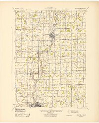
(127)- 1917 Map of Chesaning
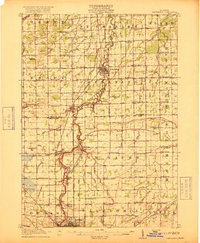 1917 Chesaning1917 Print · USGSSaginaw and Shiawassee Counties were thriving agricultural and rail hubs when this survey was completed in the mid-1910s. Genealogists and local historians can trace family roots through numerous country schoolhouses like Ziegler School and landmarks like the Sixmile Mine.4 unique versions available
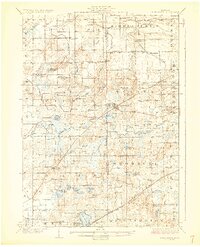
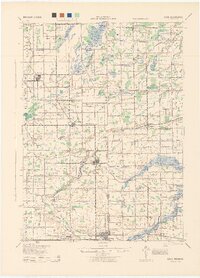
 - 1918 Map of Elsie
 1918 Elsie1918 Print · USGSCentral Michigan farmland and river valleys are captured here at the end of the Great War. Genealogists can trace family roots through numerous schoolhouses like Elba Center School and early rail stops at Carland, Bannister, and Munson Crossing.3 unique versions available
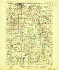
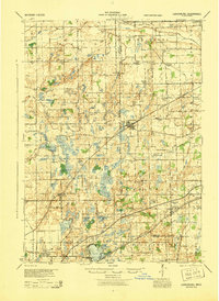
 - 1919 Map of Burt, 1959 Print
 1919 Burt1959 Print · USGSThe rural landscape between Saginaw and Flint is captured here in the years following the Great War. Genealogists can locate dozens of country schoolhouses like Marr School and Deneen School, or trace the path of the Michigan United Electric Railway.
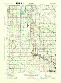
 - 1921 Map of Burt
 1921 Burt1921 Print · USGSSaginaw and Genesee Counties are captured here at the end of the Great War, showing a landscape of tight-knit farming communities and early electric transit. Researchers can trace family roots through dozens of named sites like St Michaels Church, Marr School, and the Michigan Electric Railway.2 unique versions available
 - 1922 Map of Durand
 1922 Durand1922 Print · USGSShiawassee and Genesee counties come alive in the early 1920s as a bustling junction of rail and river. Researchers can trace the sprawling Grand Trunk lines through Durand or locate family roots near the Crapo Farm and Unity Grange.4 unique versions available
 - 1926 Map of Corunna, 1958 Print
 1926 Corunna1958 Print · USGSShiawassee County in the mid-twenties shows a landscape of busy rail junctions and productive farmland. Genealogists can trace family roots through numerous rural schools like Eddy Sch and settlements including Bancroft and Shiawasseetown.2 unique versions available
 - 1928 Map of Laingsburg
 1928 Laingsburg1928 Print · USGSCentral Michigan in the late twenties shows a landscape of busy rural school districts and multiple rail lines connecting the tri-county area. Local historians can trace family locations near Octagon Sch, Reed Church, and the tracks of the Michigan Electric Railway.5 unique versions available
 - 1929 Map of Corunna
 1929 Corunna1929 Print · USGSShiawassee County thrives as a rail and industrial hub during the late twenties, centered on the growing cities of Owosso and Corunna. Genealogists can trace family roots through dozens of rural landmarks like Bennington No 1 School, Shiawasseetown, and the Electric Railway route.3 unique versions available
 - 1943 Map of Burt
 1943 Burt1943 Print · USGSThe rural borders of Saginaw and Genesee counties come alive in the 1940s as the Flint River winds past growing farm towns. Genealogists and historians can trace dozens of family-named schoolhouses and crossroads, from St Michaels Ch to the rail hubs of Burt and Montrose.
 - 1943 Map of Chesaning
 1943 Chesaning1943 Print · USGSMid-Michigan's river-driven economy is on display here during the early 1940s, as the Shiawassee River winds through fertile farm country. Genealogists and researchers can locate dozens of country schoolhouses like Albert Sch and trace industrial sites including the Sixmile Mine.
 - 1943 Map of Durand
 1943 Durand1943 Print · USGSMid-century Shiawassee and Genesee Counties are mapped here during a period of agricultural stability and rail expansion. Genealogists can trace family farm locations near Crapo Farm or locate rural schools like Doane Sch and Church Sch.
 - 1943 Map of Elsie, 1944 Print
 1943 Elsie1944 Print · USGSMid-century central Michigan is captured here during the wartime years, showing the intersection of four counties. Genealogists can locate dozens of country schoolhouses like Kelsey Sch and Munson Sch or trace family roots in settlements such as Elsie, Ashley, and Bannister.
 - 1944 Map of Laingsburg
 1944 Laingsburg1944 Print · USGSMid-Michigan farm country and wetlands are captured here just after the war, centered on the rail hub of Laingsburg. Researchers can trace nineteenth-century school districts like Octagon Sch and find family plots at South Ovid Cem or Stilson Cem.
 - 1944 Map of Corunna
 1944 Corunna1944 Print · USGSMid-Michigan farming and industry converge in the 1940s as major rail lines like the Ann Arbor and Grand Trunk link the countryside. Researchers can trace dozens of rural school sites, from Octagon Sch to Hawkins Sch, alongside the waters of the Shiawassee River.
 - 1954 Map of Detroit
 1954 Detroit1954 Print · USGSThe Detroit metro and its Ontario neighbors are shown at the height of the mid-century industrial era, just as the suburbs were rapidly expanding. Researchers can trace the massive rail networks of the Wabash Railroad or locate landmarks like Grosse Ile and Selfridge Air Force Base.
 - 1954 Map of Midland, 1967 Print
 1954 Midland1967 Print · USGSMid-Michigan at the peak of the post-war era shows a landscape balancing industrial growth in Midland with the deep timberlands of the Manistee National Forest. Researchers can trace the legacy of the timber and rail era along the Pennsylvania RR or find family roots in river towns like Chesaning and Big Rapids.4 unique versions available
 - 1954 Map of Flint, 1968 Print
 1954 Flint1968 Print · USGSThe industrial corridor and fertile Thumb region of Michigan come alive in this mid-century survey. Genealogists and historians can trace the rail networks of the Grand Trunk, locate established settlements like Bad Axe and Sandusky, or explore the 1950s shoreline along Saginaw Bay.4 unique versions available
 - 1958 Map of Flint
 1958 Flint1958 Print · USGSThe Michigan Thumb and the Saginaw Valley are captured here during the height of the post-war industrial era. Researchers can trace the complex rail networks of the Grand Trunk Western or locate mid-century landmarks like Lakeport State Park and the port at Bay City.2 unique versions available
 - 1958 Map of Midland
 1958 Midland1958 Print · USGSCentral Michigan in the late fifties is captured here during a period of transition for its university towns and industrial hubs. Genealogists and researchers can trace family lines through old rail-stop towns like Breckenridge and Chesaning or locate property near the Muskegon River and Prairie Farm.
 - 1958 Map of Grand Rapids, 1973 Print
 1958 Grand Rapids1973 Print · USGSSouthern Michigan at the peak of the postwar era shows a landscape of burgeoning cities and new interstate highways. Trace family roots and regional growth in Grand Rapids, Battle Creek, and the glacial lake country around Gun Lake or Gull Lake.2 unique versions available
 - 1959 Map of Midland
 1959 Midland1959 Print · USGSMid-century Michigan comes alive in this survey of the central Lower Peninsula, from the streets of Grand Rapids to the Houghton Lake timberlands. Genealogists and rail fans can trace the Ann Arbor RR and Chesapeake and Ohio RR through towns like Big Rapids and Mount Pleasant.
 - 1961 Map of Grand Rapids
 1961 Grand Rapids1961 Print · USGSSouthern Michigan at the dawn of the 1960s reveals a region shaped by major river systems and a robust rail network. Trace mid-century industrial growth and land use from Grand Rapids to the Fort Custer Military Reservation and Gun Lake.
 - 1961 Map of Detroit, 1973 Print
 1961 Detroit1973 Print · USGSThe international border between Michigan and Ontario was a bustling industrial corridor in the early sixties. Researchers can trace the transit networks and riverfront infrastructure connecting Detroit to Windsor via the Detroit-Windsor Tunnel and major air hubs like Willow Run Airport.2 unique versions available
 - 1962 Map of Grand Rapids
 1962 Grand Rapids1962 Print · USGSMid-century Southern Michigan is mapped here at a time of massive growth, showing the expanding urban footprints of Grand Rapids and Lansing. Researchers can trace the legacy of the Grand Trunk Western RR, find historic boundaries of the Fort Custer Military Reservation, or locate sporting camps around Gun Lake.2 unique versions available
 - 1965 Map of Detroit
 1965 Detroit1965 Print · USGSThe industrial corridor between Michigan and Ontario is captured here at mid-century, showing the dense rail and river networks of the Great Lakes. Local historians can trace the paths of the Grand Trunk Western RR and locate key landmarks like Selfridge Air Force Base and Grosse Ile.
Showing maps 1-25 of 127
Top cities of Shiawassee County
Frequently asked questions
- What are the different types of historical maps available for Shiawassee County?
- What is the oldest map of Shiawassee County?
- Where can I purchase historical maps of Shiawassee County for my home or office?
- Where can I download high-res historical maps of Shiawassee County?
- Are there historical topographic maps available for Shiawassee County?
- Is there historical aerial imagery available for Shiawassee County?
- Where are historical maps of Shiawassee County sourced from?