1970s Maps of Bennington Township, Michigan
Explore 4 historic maps of Bennington Township from the 1970s. These maps offer a rare glimpse into what life looked like during the 1970s — showing old roads, neighborhoods, homes, and landmarks that have changed or disappeared over time.
Whether you're researching your family's past, planning a metal detecting trip, or studying how Bennington Township's landscape evolved across the 1970s, these high-resolution maps are a powerful tool for exploring the history of this region.
- Focus on a specific era: All maps on this page are from the 1970s, giving you a focused view of this time period.
- See what’s changed: Compare century-old streets, trails, and buildings to today's modern landscape using overlays and satellite layers.
- Research with precision: Use these maps for genealogy, historical research, land use analysis, or educational projects.
- View, download, or print: Maps are fully viewable online in high resolution, and can be downloaded or printed for your own records.
Start exploring Bennington Township's history through authentic maps from the 1970s. This is your window into the past.
Bennington Township, MI maps
(4)- 1972 Map of Laingsburg, 1974 Print
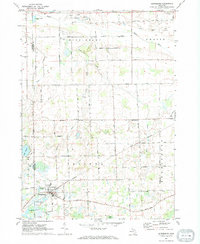 1972 Laingsburg1974 Print · USGSShiawassee County in the early seventies centers on the rail-linked hub of Laingsburg and the rural reaches of Ovid. Trace family history and land use through Oak Grove Cem, the Middlebury Ch, and the many Gravel Pits along the Maple River.
 - 1972 Map of Shaftsburg, 1974 Print
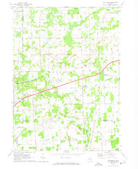 1972 Shaftsburg1974 Print · USGSShiawassee County's rural character is preserved here in the early seventies, centered on the village of Shaftsburg. Researchers can trace family roots at Oak Plain Cem, locate the Perry Sch, or follow the Grand Trunk Western rail line.
 - 1972 Map of Perry, 1975 Print
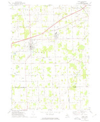 1972 Perry1975 Print · USGSMid-century Perry and Morrice are captured here as the Grand Trunk Western railroad defines the local industry. Researchers can trace family roots through Roselawn Cem or locate the private Dysinger Landing Strip.
 - 1972 Map of Owosso South, 1975 Print
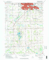 1972 Owosso South1975 Print · USGSMid-Michigan settlement and industry converge along the Shiawassee River during the early seventies. Researchers can trace local lineage through Oak Hill Cem or explore the campus footprints of John Wesley College and Spring Vale Academy.2 unique versions available
End of results
Showing maps 1-4 of 4
Top cities near Bennington Township
- Lansing historical maps
- East Lansing historical maps
- Owosso historical maps
- Handy Township historical maps
- Howell Township historical maps
- Durand historical maps
See more
Top neighborhoods of Bennington Township
Frequently asked questions
- What are the different types of historical maps available for Bennington Township?
- What is the oldest map of Bennington Township?
- Where can I purchase historical maps of Bennington Township for my home or office?
- Where can I download high-res historical maps of Bennington Township?
- Are there historical topographic maps available for Bennington Township?
- Is there historical aerial imagery available for Bennington Township?
- Where are historical maps of Bennington Township sourced from?