1980s Maps of South Haven, Michigan
Explore 3 historic maps of South Haven from the 1980s. These maps offer a rare glimpse into what life looked like during the 1980s — showing old roads, neighborhoods, homes, and landmarks that have changed or disappeared over time.
Whether you're researching your family's past, planning a metal detecting trip, or studying how South Haven's landscape evolved across the 1980s, these high-resolution maps are a powerful tool for exploring the history of this region.
- Focus on a specific era: All maps on this page are from the 1980s, giving you a focused view of this time period.
- See what’s changed: Compare century-old streets, trails, and buildings to today's modern landscape using overlays and satellite layers.
- Research with precision: Use these maps for genealogy, historical research, land use analysis, or educational projects.
- View, download, or print: Maps are fully viewable online in high resolution, and can be downloaded or printed for your own records.
Start exploring South Haven's history through authentic maps from the 1980s. This is your window into the past.
South Haven, MI maps
(3)- 1981 Map of Covert, 1982 Print
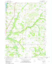
 1981 Covert1982 Print · USGSCoastal Van Buren County in the early eighties shows a landscape of dunes and developing lakeside communities along the lake. Researchers can trace family sites near Fish Corners, the Chesapeake and Ohio tracks, and the Fish Cem.
 - 1981 Map of Lacota, 1982 Print
 1981 Lacota1982 Print · USGSLake Michigan's shoreline meets the rural townships of Casco and Geneva in the early eighties. Genealogists and local historians can trace family plots at Stuller Cemetery or Chambers Cemetery and explore the historic crossroads of Kibbie and Lacota.
 - 1981 Map of South Haven, 1982 Print
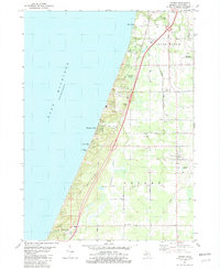
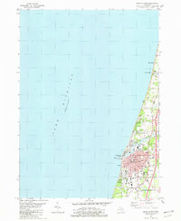 1981 South Haven1982 Print · USGSThe Lake Michigan shoreline of Van Buren County comes into focus in the early 1980s, centered on the busy port of South Haven. Genealogists and local historians can trace the town's growth through landmarks like the Hebrew Cemetery, the Chesapeake and Ohio rail line, and Miami Park.
End of results
Showing maps 1-3 of 3
Top cities near South Haven
- Lee historical maps
- Covert historical maps
- Ganges historical maps
- Hartford historical maps
- Bangor historical maps
- Watervliet historical maps
See more
Top neighborhoods of South Haven
Frequently asked questions
- What are the different types of historical maps available for South Haven?
- What is the oldest map of South Haven?
- Where can I purchase historical maps of South Haven for my home or office?
- Where can I download high-res historical maps of South Haven?
- Are there historical topographic maps available for South Haven?
- Is there historical aerial imagery available for South Haven?
- Where are historical maps of South Haven sourced from?