1990s Maps of Dexter Township, Michigan
Explore 3 historic maps of Dexter Township from the 1990s. These maps offer a rare glimpse into what life looked like during the 1990s — showing old roads, neighborhoods, homes, and landmarks that have changed or disappeared over time.
Whether you're researching your family's past, planning a metal detecting trip, or studying how Dexter Township's landscape evolved across the 1990s, these high-resolution maps are a powerful tool for exploring the history of this region.
- Focus on a specific era: All maps on this page are from the 1990s, giving you a focused view of this time period.
- See what’s changed: Compare century-old streets, trails, and buildings to today's modern landscape using overlays and satellite layers.
- Research with precision: Use these maps for genealogy, historical research, land use analysis, or educational projects.
- View, download, or print: Maps are fully viewable online in high resolution, and can be downloaded or printed for your own records.
Start exploring Dexter Township's history through authentic maps from the 1990s. This is your window into the past.
Dexter Township, MI maps
(3)- 1996 Map of Gregory, 1999 Print
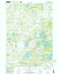 1996 Gregory1999 Print · USGSThe rural townships of Livingston and Washtenaw counties appear here in the mid-1990s, defined by glacial lakes and public recreation lands. Researchers can trace historic family burial sites at Unadilla Cem, the path of the Old RR Grade, and the quiet hamlets of Gregory and Anderson.
 - 1996 Map of Dexter, 2000 Print
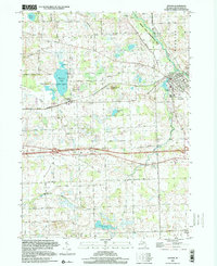 1996 Dexter2000 Print · USGSThe village of Dexter and the surrounding townships of Lima and Webster are shown in the late nineties as a blend of riverfront parkland and rural crossroads. Genealogists can trace family roots through several documented burial grounds like St Joseph Cem, Lima Cem, and Parker Cem.
 - 1996 Map of Pinckney, 2000 Print
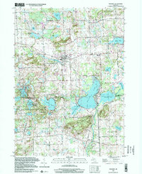 1996 Pinckney2000 Print · USGSLivingston and Washtenaw counties meet here in the late twentieth century, centered on the village of Pinckney and the surrounding glacial lake district. Genealogists and researchers can trace family landmarks along Territorial Road and locate rural sites like Hudson Cem and the settlement of Dover.
End of results
Showing maps 1-3 of 3
Top cities near Dexter Township
- Ann Arbor historical maps
- Pittsfield Charter Township historical maps
- Hamburg Township historical maps
- Genoa Charter Township historical maps
- Green Oak Charter Township historical maps
- Brighton Charter Township historical maps
See more
Top neighborhoods of Dexter Township
Frequently asked questions
- What are the different types of historical maps available for Dexter Township?
- What is the oldest map of Dexter Township?
- Where can I purchase historical maps of Dexter Township for my home or office?
- Where can I download high-res historical maps of Dexter Township?
- Are there historical topographic maps available for Dexter Township?
- Is there historical aerial imagery available for Dexter Township?
- Where are historical maps of Dexter Township sourced from?