1910s Maps of Waukenabo, Minnesota
Explore 2 historic maps of Waukenabo from the 1910s. These maps offer a rare glimpse into what life looked like during the 1910s — showing old roads, neighborhoods, homes, and landmarks that have changed or disappeared over time.
Whether you're researching your family's past, planning a metal detecting trip, or studying how Waukenabo's landscape evolved across the 1910s, these high-resolution maps are a powerful tool for exploring the history of this region.
- Focus on a specific era: All maps on this page are from the 1910s, giving you a focused view of this time period.
- See what’s changed: Compare century-old streets, trails, and buildings to today's modern landscape using overlays and satellite layers.
- Research with precision: Use these maps for genealogy, historical research, land use analysis, or educational projects.
- View, download, or print: Maps are fully viewable online in high resolution, and can be downloaded or printed for your own records.
Start exploring Waukenabo's history through authentic maps from the 1910s. This is your window into the past.
Waukenabo, MN maps
(2)- 1914 Map of Aitkin, 1966 Print
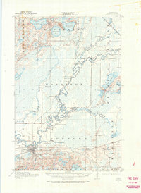 1914 Aitkin1966 Print · USGSAitkin and the surrounding wetlands are shown here just before the First World War, as the river-and-rail economy shaped the landscape. Genealogists can locate numerous rural schoolhouses and early settlements like Rossburg, Hassman, and the Lone Pine School.
 - 1915 Map of Aitkin
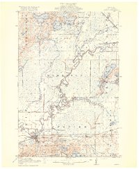 1915 Aitkin1915 Print · USGSAitkin County in the mid-1910s was a hub of river transport and rail expansion, centered on the growing village of Aitkin. You can trace the path of the Northern Pacific railroad through Rossburg and find rural landmarks like Lone Pine School and Waukenabo Lake.4 unique versions available
End of results
Showing maps 1-2 of 2
Top cities near Waukenabo
Frequently asked questions
- What are the different types of historical maps available for Waukenabo?
- What is the oldest map of Waukenabo?
- Where can I purchase historical maps of Waukenabo for my home or office?
- Where can I download high-res historical maps of Waukenabo?
- Are there historical topographic maps available for Waukenabo?
- Is there historical aerial imagery available for Waukenabo?
- Where are historical maps of Waukenabo sourced from?