1960s Maps of Anoka County, Minnesota
Explore 11 historic maps of Anoka County from the 1960s. These maps offer a rare glimpse into what life looked like during the 1960s — showing old roads, neighborhoods, homes, and landmarks that have changed or disappeared over time.
Whether you're researching your family's past, planning a metal detecting trip, or studying how Anoka County's landscape evolved across the 1960s, these high-resolution maps are a powerful tool for exploring the history of this region.
- Focus on a specific era: All maps on this page are from the 1960s, giving you a focused view of this time period.
- See what’s changed: Compare century-old streets, trails, and buildings to today's modern landscape using overlays and satellite layers.
- Research with precision: Use these maps for genealogy, historical research, land use analysis, or educational projects.
- View, download, or print: Maps are fully viewable online in high resolution, and can be downloaded or printed for your own records.
Start exploring Anoka County's history through authentic maps from the 1960s. This is your window into the past.
Anoka County, MN maps
(11)- 1961 Map of Lake Fremont, 1963 Print
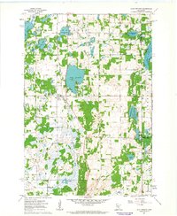 1961 Lake Fremont1963 Print · USGSSherburne County is shown here in the early sixties as a region of dense glacial lakes and burgeoning township life. Researchers can find family sites near Zimmerman, Livonia Cem, and the old Community Hall.3 unique versions available
 - 1961 Map of Elk River, 1963 Print
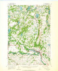
 1961 Elk River1963 Print · USGSElk River and the banks of the Mississippi River are captured here in the early sixties as the region's rail and water network defined local life. Genealogists and local historians can trace landmarks like St Andrews Cem, St Johns Sch, and the riverside powerplant.3 unique versions available
 - 1961 Map of Elk River, 1965 Print
 1961 Elk River1965 Print · USGSThe Elk River and Mississippi River valleys in the early 1960s showcase a landscape of shifting industry and conservation. Local researchers can trace family sites at Orrock Cem, find Zimmerman's post office, and locate the Sand Dunes Lookout Tower.
 - 1965 Map of Stillwater
 1965 Stillwater1965 Print · USGSThe Twin Cities and the St. Croix Valley are mapped here during a period of significant post-war growth and industrial transit. Genealogists and historians can trace rail lines like the Northern Pacific RR through towns such as Rush City, Amery, and Balsam Lake.
 - 1967 Map of Circle Pines, 1969 Print
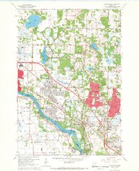
 1967 Circle Pines1969 Print · USGSThe northern Twin Cities suburbs were rapidly expanding in the late sixties, as new residential grids began to replace rural fields. Genealogists and local historians can trace early neighborhood footprints near Johnsville, Lexington, and the Anoka County Airport.4 unique versions available
 - 1967 Map of New Brighton, 1969 Print
 1967 New Brighton1969 Print · USGSThe northern Minneapolis suburbs transition from industrial rail hubs to residential lakefronts in the late sixties. Genealogists and historians can trace cemetery boundaries at St Marys Cem, follow the Soo Line tracks, or locate the sprawling Twin Cities Army Ammunition Plant.5 unique versions available
 - 1967 Map of Minneapolis North, 1969 Print
 1967 Minneapolis North1969 Print · USGSNorth Minneapolis and its growing suburbs are captured here during the late sixties, a period of massive residential and highway expansion. Researchers can locate family sites near Crystal Lake Cemetery, trace the old Soo Line tracks, or explore the grounds of the Northern Ordnance Plant.5 unique versions available
 - 1967 Map of Coon Rapids, 1969 Print
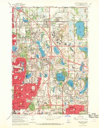
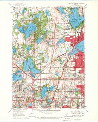
 1967 Coon Rapids1969 Print · USGSGreater Minneapolis-Saint Paul expanded rapidly in the late sixties as the residential corridors of Anoka County took shape. Genealogists and local historians can trace the early footprints of Northdale, the Anoka-Ramsey State Junior College, and landmarks like the Radio Tower (WCCO).5 unique versions available
 - 1967 Map of Centerville, 1969 Print
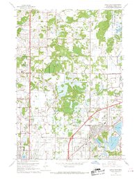
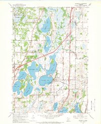 1967 Centerville1969 Print · USGSThe Anoka County lake region in the late sixties reveals a landscape of water-dependent industry and conservation. You can trace the Northern Pacific line through Hugo or locate local landmarks like the Seaplane Base and St Genevieve Cem.4 unique versions available
 - 1967 Map of Anoka, 1969 Print
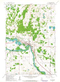
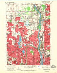
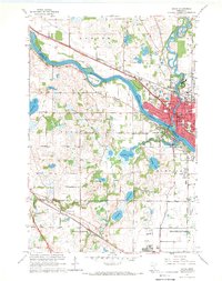 1967 Anoka1969 Print · USGSAnoka and Champlin sit at a pivotal river junction in the late sixties as suburban growth begins to reach the surrounding prairies. Researchers can trace the layout of the State Hospital or find family plots at Oakwood Cem and Maple Grove Cem.4 unique versions available
 - 1967 Map of White Bear Lake West, 1969 Print
 1967 White Bear Lake West1969 Print · USGSSuburban Ramsey County comes into focus in the late sixties as residential growth surrounds its many glacial lakes. Researchers can trace the development of Vadnais Heights and Little Canada, or locate local landmarks like Benson Airport and the Soo Line railroad.5 unique versions available
End of results
Showing maps 1-11 of 11
Top cities of Anoka County
- Coon Rapids historical maps
- Blaine historical maps
- Andover historical maps
- Ramsey historical maps
- Fridley historical maps
- Lino Lakes historical maps
See more
Frequently asked questions
- What are the different types of historical maps available for Anoka County?
- What is the oldest map of Anoka County?
- Where can I purchase historical maps of Anoka County for my home or office?
- Where can I download high-res historical maps of Anoka County?
- Are there historical topographic maps available for Anoka County?
- Is there historical aerial imagery available for Anoka County?
- Where are historical maps of Anoka County sourced from?