1970s Maps of Anoka County, Minnesota
Explore 9 historic maps of Anoka County from the 1970s. These maps offer a rare glimpse into what life looked like during the 1970s — showing old roads, neighborhoods, homes, and landmarks that have changed or disappeared over time.
Whether you're researching your family's past, planning a metal detecting trip, or studying how Anoka County's landscape evolved across the 1970s, these high-resolution maps are a powerful tool for exploring the history of this region.
- Focus on a specific era: All maps on this page are from the 1970s, giving you a focused view of this time period.
- See what’s changed: Compare century-old streets, trails, and buildings to today's modern landscape using overlays and satellite layers.
- Research with precision: Use these maps for genealogy, historical research, land use analysis, or educational projects.
- View, download, or print: Maps are fully viewable online in high resolution, and can be downloaded or printed for your own records.
Start exploring Anoka County's history through authentic maps from the 1970s. This is your window into the past.
Anoka County, MN maps
(9)- 1974 Map of Crown, 1976 Print
 1974 Crown1976 Print · USGSThe Isanti and Anoka county line in the mid-seventies reveals a landscape of protected wetlands and rural outposts. Researchers can trace local genealogy and land use at Crown, Zion Cem, and the Bar None Ranch.
 - 1974 Map of Cedar, 1976 Print
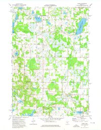
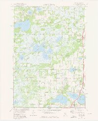
 1974 Cedar1976 Print · USGSAnoka County undergoes steady suburban transformation in the mid-seventies as new road grids expand around traditional settlements. Genealogists and local historians can trace the foundations of Oak Grove and Ham Lake while locating Pierce Cem and St Patricks Ch.2 unique versions available
 - 1974 Map of Nowthen, 1976 Print
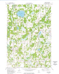
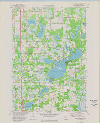
 1974 Nowthen1976 Print · USGSAnoka County's lake-strewn landscape is captured here in the mid-seventies, showing the rural communities of Burns and Ramsey. Researchers can locate family landmarks such as Lakeview Cem, Trott Brook Ch, and the original Townhall in Nowthen.2 unique versions available
 - 1974 Map of St Francis, 1976 Print
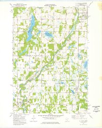 1974 St Francis1976 Print · USGSThe Rum River valley in the mid-seventies shows a landscape of growing townships and preserved wetlands along the Isanti and Anoka county line. Researchers can trace the Burlington Northern rail corridor and find local landmarks like Strike Cem, Boys Ranch, and St Johns Ch.
 - 1974 Map of Typo Lake, 1976 Print
 1974 Typo Lake1976 Print · USGSThe marshy lake country of Isanti and Anoka Counties is meticulously mapped in the mid-seventies, showing a landscape defined by water and drainage. Family historians can locate rural landmarks like Oxford Cem, St Johns Ch, and the small settlement of Weber.
 - 1974 Map of Coon Lake Beach, 1976 Print
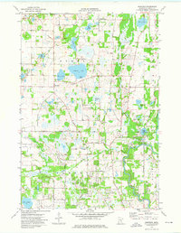
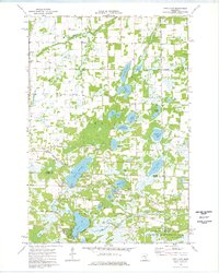
 1974 Coon Lake Beach1976 Print · USGSAnoka County's lake-rich landscape is captured in the mid-seventies, showing the growth of Coon Lake Beach and Soderville among the glacial basins. Researchers can trace local roots through landmarks like Oak Leaf Cem, McKinley Sch, and the Old Railroad Grade.2 unique versions available
 - 1974 Map of Linwood, 1976 Print
 1974 Linwood1976 Print · USGSAnoka and Chisago counties are shown during the mid-seventies, featuring the expansive Carlos Avery State Wildlife Management Area. Researchers can trace old family sites near Linwood Sch or locate ancestors at Victor Hill Cem and Oak Park Cem.3 unique versions available
 - 1974 Map of Isanti, 1976 Print
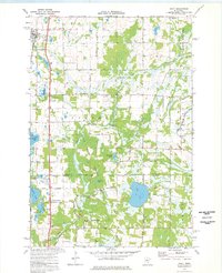 1974 Isanti1976 Print · USGSThe rural corridor between Isanti and East Bethel is captured here in the mid-seventies as the rail-side village meets a landscape of wetlands and small farms. Researchers can trace local heritage at Old Bethel Cem, Aetna Ch, and family-named landmarks like Coopers Corner.
 - 1975 Map of Stillwater
 1975 Stillwater1975 Print · USGSThe Twin Cities and the St. Croix Valley are captured in the mid-seventies, showing the urban growth of Minneapolis and St Paul. Researchers can trace old rail corridors of the Northern Pacific RR and locate tribal lands at the Mille Lacs Indian Reservation.2 unique versions available
End of results
Showing maps 1-9 of 9
Top cities of Anoka County
- Coon Rapids historical maps
- Blaine historical maps
- Andover historical maps
- Ramsey historical maps
- Fridley historical maps
- Lino Lakes historical maps
See more
Frequently asked questions
- What are the different types of historical maps available for Anoka County?
- What is the oldest map of Anoka County?
- Where can I purchase historical maps of Anoka County for my home or office?
- Where can I download high-res historical maps of Anoka County?
- Are there historical topographic maps available for Anoka County?
- Is there historical aerial imagery available for Anoka County?
- Where are historical maps of Anoka County sourced from?