1990s Maps of Blackduck, Minnesota
Explore 1 historic maps of Blackduck from the 1990s. These maps offer a rare glimpse into what life looked like during the 1990s — showing old roads, neighborhoods, homes, and landmarks that have changed or disappeared over time.
Whether you're researching your family's past, planning a metal detecting trip, or studying how Blackduck's landscape evolved across the 1990s, these high-resolution maps are a powerful tool for exploring the history of this region.
- Focus on a specific era: All maps on this page are from the 1990s, giving you a focused view of this time period.
- See what’s changed: Compare century-old streets, trails, and buildings to today's modern landscape using overlays and satellite layers.
- Research with precision: Use these maps for genealogy, historical research, land use analysis, or educational projects.
- View, download, or print: Maps are fully viewable online in high resolution, and can be downloaded or printed for your own records.
Start exploring Blackduck's history through authentic maps from the 1990s. This is your window into the past.
Blackduck, MN maps
(1)- 1996 Map of Blackduck, 1998 Print
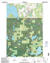 1996 Blackduck1998 Print · USGSThe town of Blackduck is seen here in the mid-nineties, situated between deep state and national forests and a massive network of glacial lakes. Researchers can locate the Rabideau CCC Camp Historic Site, Lakeview Cemetery, and the Blackduck Lookout.
End of results
Showing maps 1-1 of 1
Top cities near Blackduck
- Hines historical maps
- Kelliher historical maps
- Tenstrike historical maps
- Shooks historical maps
- Langor historical maps
- Quiring historical maps
See more
Frequently asked questions
- What are the different types of historical maps available for Blackduck?
- What is the oldest map of Blackduck?
- Where can I purchase historical maps of Blackduck for my home or office?
- Where can I download high-res historical maps of Blackduck?
- Are there historical topographic maps available for Blackduck?
- Is there historical aerial imagery available for Blackduck?
- Where are historical maps of Blackduck sourced from?