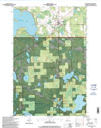
1996 Map of Blackduck
USGS Topo · Published 1998About this map
Blackduck serves as the primary hub in this northern Minnesota landscape, surrounded by the extensive woods of the Chippewa National Forest and Blackduck State Forest. The geography is defined by a dense network of glacial lakes and wetlands, including the expansive Blackduck Lake and the smaller Gilstad Lake and Rabideau Lake. Near the southern edge of the sheet, the Rabideau CCC Camp Historic Site preserves a significant piece of Great Depression-era heritage, complemented by the Camp Rabideau CCC Trail. These features highlight the region's history of forest management and public works during the mid-20th century. Local genealogists may find value in the location of Lakeview Cemetery and the Township Cemetery, while the distribution of forest roads and landmarks like the Blackduck Lookout illustrate the intersection of conservation and community in Beltrami County.
Find a feature on this map
44 named features on this map. Tap any name to fly to it.
Don’t see what you’re looking for? This feature index may not catch every label — zoom into the map to look around manually.
Map Details
Editions of this 1996 Blackduck Map
This is the sole edition of this map. No revisions or reprints were ever made.
Other maps of this area

1919 · Rosy
USGS Topo · 1:62,500

1919 · Quiring
USGS Topo · 1:62,500

1919 · Bridgie
USGS Topo · 1:62,500

1924 · Bridgie
USGS Topo · 1:62,500

1954 · Bemidji
USGS Topo · 1:250,000

1957 · Bemidji
USGS Topo · 1:250,000

1958 · Bemidji
USGS Topo · 1:250,000

1971 · Gimmer Lake
USGS Topo · 1:24,000

1971 · Funkley
USGS Topo · 1:24,000

1971 · Decker Lake
USGS Topo · 1:24,000