1970s Maps of Solway, Minnesota
Explore 2 historic maps of Solway from the 1970s. These maps offer a rare glimpse into what life looked like during the 1970s — showing old roads, neighborhoods, homes, and landmarks that have changed or disappeared over time.
Whether you're researching your family's past, planning a metal detecting trip, or studying how Solway's landscape evolved across the 1970s, these high-resolution maps are a powerful tool for exploring the history of this region.
- Focus on a specific era: All maps on this page are from the 1970s, giving you a focused view of this time period.
- See what’s changed: Compare century-old streets, trails, and buildings to today's modern landscape using overlays and satellite layers.
- Research with precision: Use these maps for genealogy, historical research, land use analysis, or educational projects.
- View, download, or print: Maps are fully viewable online in high resolution, and can be downloaded or printed for your own records.
Start exploring Solway's history through authentic maps from the 1970s. This is your window into the past.
Solway, MN maps
(2)- 1972 Map of Solway, 1974 Print
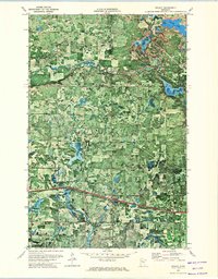 1972 Solway1974 Print · USGSBeltrami and Clearwater counties appear in the early 1970s as timber and transit corridors define the rural landscape. Genealogists and local historians can trace family locations near Solway Cem or follow the Old Indian Treaty Boundary and the Old Railroad Grade.
 - 1972 Map of Wilton, 1974 Print
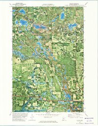 1972 Wilton1974 Print · USGSBeltrami County’s lake-studded woodlands are captured in the early 1970s, revealing the dense canopy and shoreline detail of the Mississippi Headwaters State Forest. Researchers can trace the Old Indian Treaty Boundary and locate rural landmarks like Trinity Ch and the Pinewood Cemetery.
End of results
Showing maps 1-2 of 2
Top cities near Solway
Frequently asked questions
- What are the different types of historical maps available for Solway?
- What is the oldest map of Solway?
- Where can I purchase historical maps of Solway for my home or office?
- Where can I download high-res historical maps of Solway?
- Are there historical topographic maps available for Solway?
- Is there historical aerial imagery available for Solway?
- Where are historical maps of Solway sourced from?