1940s Maps of Benton County, Minnesota
Explore 2 historic maps of Benton County from the 1940s. These maps offer a rare glimpse into what life looked like during the 1940s — showing old roads, neighborhoods, homes, and landmarks that have changed or disappeared over time.
Whether you're researching your family's past, planning a metal detecting trip, or studying how Benton County's landscape evolved across the 1940s, these high-resolution maps are a powerful tool for exploring the history of this region.
- Focus on a specific era: All maps on this page are from the 1940s, giving you a focused view of this time period.
- See what’s changed: Compare century-old streets, trails, and buildings to today's modern landscape using overlays and satellite layers.
- Research with precision: Use these maps for genealogy, historical research, land use analysis, or educational projects.
- View, download, or print: Maps are fully viewable online in high resolution, and can be downloaded or printed for your own records.
Start exploring Benton County's history through authentic maps from the 1940s. This is your window into the past.
Benton County, MN maps
(2)- 1948 Map of Pierz, 1967 Print
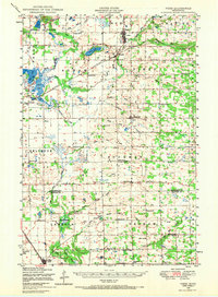 1948 Pierz1967 Print · USGSMorrison and Benton Counties in the late 1940s are characterized by a dense network of rail lines and rural school districts. Genealogists can trace family roots through numerous numbered schools, St Johns Church, and local landmarks like Rosemarks Store.
 - 1948 Map of Little Falls, 1973 Print
 1948 Little Falls1973 Print · USGSMid-century Central Minnesota comes alive in this survey of the river valleys and rail towns north of St. Cloud. Genealogists can locate family landmarks like St Mary Church, Pike Creek Town Hall, and numerous rural schools from Bowlus to Royalton.
End of results
Showing maps 1-2 of 2
Top cities of Benton County
Frequently asked questions
- What are the different types of historical maps available for Benton County?
- What is the oldest map of Benton County?
- Where can I purchase historical maps of Benton County for my home or office?
- Where can I download high-res historical maps of Benton County?
- Are there historical topographic maps available for Benton County?
- Is there historical aerial imagery available for Benton County?
- Where are historical maps of Benton County sourced from?