1970s Maps of Langola Township, Minnesota
Explore 3 historic maps of Langola Township from the 1970s. These maps offer a rare glimpse into what life looked like during the 1970s — showing old roads, neighborhoods, homes, and landmarks that have changed or disappeared over time.
Whether you're researching your family's past, planning a metal detecting trip, or studying how Langola Township's landscape evolved across the 1970s, these high-resolution maps are a powerful tool for exploring the history of this region.
- Focus on a specific era: All maps on this page are from the 1970s, giving you a focused view of this time period.
- See what’s changed: Compare century-old streets, trails, and buildings to today's modern landscape using overlays and satellite layers.
- Research with precision: Use these maps for genealogy, historical research, land use analysis, or educational projects.
- View, download, or print: Maps are fully viewable online in high resolution, and can be downloaded or printed for your own records.
Start exploring Langola Township's history through authentic maps from the 1970s. This is your window into the past.
Langola Township, MN maps
(3)- 1974 Map of Little Rock Lake, 1976 Print
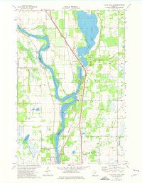 1974 Little Rock Lake1976 Print · USGSBenton and Stearns County river life in the mid-seventies centers on the winding Mississippi River and the shores of Little Rock Lake. Researchers can trace early transportation and industry through the Burlington Northern line and local landmarks like Rice Cem and Watab.3 unique versions available
 - 1978 Map of Royalton
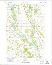 1978 Royalton1978 Print · USGSThe Mississippi and Platte rivers converge in this late 1970s survey of central Minnesota, capturing the rail-and-river economy of the day. Genealogists can trace local roots at Holy Trinity Cem and Royalton Cem, or locate family landmarks near North Prairie and Blanchard Dam.
 - 1978 Map of Rice
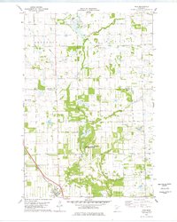 1978 Rice1978 Print · USGSBenton County in the late seventies is captured here as a landscape of rural townships and winding waterways. Researchers can trace the Burlington Northern rail line through Rice, locate Skounter Hill, or explore the Sartell Swamp wetlands.
End of results
Showing maps 1-3 of 3
Top cities near Langola Township
- St. Cloud historical maps
- Saint Cloud historical maps
- Sauk Rapids historical maps
- Sartell historical maps
- Little Falls historical maps
- Saint Joseph historical maps
See more
Frequently asked questions
- What are the different types of historical maps available for Langola Township?
- What is the oldest map of Langola Township?
- Where can I purchase historical maps of Langola Township for my home or office?
- Where can I download high-res historical maps of Langola Township?
- Are there historical topographic maps available for Langola Township?
- Is there historical aerial imagery available for Langola Township?
- Where are historical maps of Langola Township sourced from?