1970s Maps of Blue Earth County, Minnesota
Explore 8 historic maps of Blue Earth County from the 1970s. These maps offer a rare glimpse into what life looked like during the 1970s — showing old roads, neighborhoods, homes, and landmarks that have changed or disappeared over time.
Whether you're researching your family's past, planning a metal detecting trip, or studying how Blue Earth County's landscape evolved across the 1970s, these high-resolution maps are a powerful tool for exploring the history of this region.
- Focus on a specific era: All maps on this page are from the 1970s, giving you a focused view of this time period.
- See what’s changed: Compare century-old streets, trails, and buildings to today's modern landscape using overlays and satellite layers.
- Research with precision: Use these maps for genealogy, historical research, land use analysis, or educational projects.
- View, download, or print: Maps are fully viewable online in high resolution, and can be downloaded or printed for your own records.
Start exploring Blue Earth County's history through authentic maps from the 1970s. This is your window into the past.
Blue Earth County, MN maps
(8)- 1974 Map of Mankato West, 1976 Print
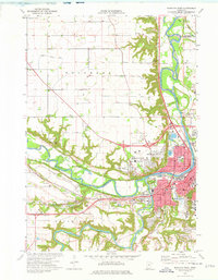 1974 Mankato West1976 Print · USGSThe Minnesota River valley comes alive in the 1970s, showcasing the expansion of Mankato and North Mankato. Genealogists can locate Belgrade Cem and Herns-Oak Grove Cem or trace landmarks like Minneopa Falls.2 unique versions available
 - 1974 Map of Madison Lake, 1976 Print
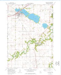
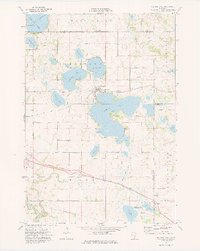 1974 Madison Lake1976 Print · USGSBlue Earth County’s lake country is captured here in the mid-seventies, showing the lakeside town of Madison Lake at a transitional moment. Genealogists and local historians can trace family locations near Marysburg, Smiths Mill, and the grounds of Calvary Cem.
 - 1974 Map of Mankato East, 1976 Print
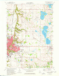 1974 Mankato East1976 Print · USGSMankato and its surrounding lake country are shown during a decade of collegiate and industrial growth in the mid-seventies. Researchers can locate numerous family burial sites at Calvary Cemetery and Sugar Grove Cem or trace the early paths of the Chicago and North Western railroad.2 unique versions available
 - 1974 Map of St Clair, 1976 Print
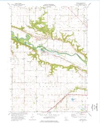
 1974 St Clair1976 Print · USGSBlue Earth County's agricultural and rail landscape is preserved here during the mid-seventies, showing the towns of St Clair and Pemberton in detail. Researchers can trace the Chicago Milwaukee St Paul and Pacific line and locate family burial sites at McPherson Cem or St Johns Cem.
 - 1974 Map of Good Thunder, 1976 Print
 1974 Good Thunder1976 Print · USGSBlue Earth County in the mid-seventies is defined by the winding river valleys of the Maple and Le Sueur rivers. Genealogists and historians can trace family roots at Calvary Cem and St Johns Cem, or locate landmarks like the Holberg Dam and the County Home.
 - 1974 Map of Judson, 1976 Print
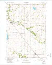
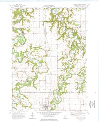
 1974 Judson1976 Print · USGSBlue Earth and Nicollet counties are captured here in the mid-seventies as the rail-and-river economy shaped the valley. Genealogists can trace family sites at Jerusalem Ch, Zion Cem, and the small settlement of Judson along the Chicago and North Western line.
 - 1974 Map of Lake Crystal, 1976 Print
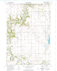
 1974 Lake Crystal1976 Print · USGSLake Crystal and Garden City are captured in the mid-1970s, showcasing the intricate water systems and rail lines of Blue Earth County. Genealogists and local historians can locate Holy Family Cem, Robinson Park, and the County Fairground among the riverbeds.
 - 1974 Map of Beauford, 1976 Print
 1974 Beauford1976 Print · USGSBlue Earth County in the mid-1970s shows a landscape of winding river valleys and agricultural engineering. Genealogists can trace family roots near Beauford and the Decoria Cem, while outdoorsmen can locate Rice Lake and the Le Sueur River.
End of results
Showing maps 1-8 of 8
Top cities of Blue Earth County
- Mankato historical maps
- Lake Crystal historical maps
- Eagle Lake historical maps
- Mapleton historical maps
- Rapidan historical maps
- Madison Lake historical maps
See more
Frequently asked questions
- What are the different types of historical maps available for Blue Earth County?
- What is the oldest map of Blue Earth County?
- Where can I purchase historical maps of Blue Earth County for my home or office?
- Where can I download high-res historical maps of Blue Earth County?
- Are there historical topographic maps available for Blue Earth County?
- Is there historical aerial imagery available for Blue Earth County?
- Where are historical maps of Blue Earth County sourced from?