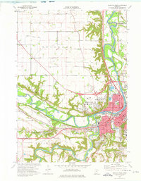
1974 Map of Mankato West
USGS Topo · Published 1976About this map
The confluence of the Minnesota River and the Blue Earth River dominates this landscape, framing the mid-1970s development of Mankato and North Mankato. The map reveals a dense network of civic and educational institutions, from the Mankato State College (Highland Campus) to local schools like Roosevelt Sch and Holy Rosary Sch. To the west, the preservation of the landscape is evident in Minneopa State Park, which protects the tiered cascades of Minneopa Falls and Minneawaukon Falls. This document captures the region just as the Interstate system was reshaping local travel, contrasting the heavy rail infrastructure of the Chicago and North Western and Milwaukee lines with modern highways. Industrial footprints like the Tank Farms near the river and numerous Gravel Pits illustrate the extractive and transport-heavy economy of the era.
Find a feature on this map
59 named features on this map. Tap any name to fly to it.
Don’t see what you’re looking for? This feature index may not catch every label — zoom into the map to look around manually.
Map Details
Editions of this 1974 Mankato West Map
2 editions found
Other maps of this area

1950 · Mankato East
USGS Topo · 1:62,500

1951 · Mankato East
USGS Topo · 1:62,500

1951 · Mankato West
USGS Topo · 1:62,500

1953 · Saint Paul
USGS Topo · 1:250,000

1953 · New Ulm
USGS Topo · 1:250,000

1957 · New Ulm
USGS Topo · 1:250,000

1958 · New Ulm
USGS Topo · 1:250,000

1959 · Saint Paul
USGS Topo · 1:250,000

1965 · North Star
USGS Topo · 1:24,000
1965 · St Peter
USGS Topo · 1:24,000