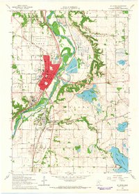
1965 Map of St Peter
USGS Topo · Published 1966About this map
St Peter and the nearby village of Kasota define this mid-1960s river landscape at the junction of Nicollet and Le Sueur counties. The Minnesota River snakes through the center of the sheet, bordered by the Traverse Des Sioux Wayside Park and extensive quarries south of Kasota. The academic and institutional character of the area is prominent, featuring the campus of Gustavus Adolphus College and the large St Peter State Hospital complex. Transportation is a key theme, with the Milwaukee Road and Chicago and North Western Railroad following the river valley. Genealogists will find numerous cemeteries including the Elim Welsh Cem and Resurrection Cem, while the eastern portion of the map transitions into a lake-dotted landscape featuring Lake Emily and Lake Washington.
Find a feature on this map
52 named features on this map. Tap any name to fly to it.
Don’t see what you’re looking for? This feature index may not catch every label — zoom into the map to look around manually.
Map Details
Editions of this 1965 St Peter Map
3 editions found
Other maps of this area

1950 · Mankato East
USGS Topo · 1:62,500

1951 · Mankato East
USGS Topo · 1:62,500

1951 · Mankato West
USGS Topo · 1:62,500

1953 · Saint Paul
USGS Topo · 1:250,000

1953 · New Ulm
USGS Topo · 1:250,000

1957 · New Ulm
USGS Topo · 1:250,000

1958 · New Ulm
USGS Topo · 1:250,000

1959 · Saint Paul
USGS Topo · 1:250,000

1965 · Cleveland
USGS Topo · 1:24,000

1965 · Norseland
USGS Topo · 1:24,000