1900s (20th Century) Maps of Eagle Lake, Minnesota
Explore 7 historic maps of Eagle Lake from the 1900s (20th Century). These maps offer a rare glimpse into what life looked like during the 1900s — showing old roads, neighborhoods, homes, and landmarks that have changed or disappeared over time.
Whether you're researching your family's past, planning a metal detecting trip, or studying how Eagle Lake's landscape evolved across the 1900s, these high-resolution maps are a powerful tool for exploring the history of this region.
- Focus on a specific era: All maps on this page are from the 1900s, giving you a focused view of this time period.
- See what’s changed: Compare century-old streets, trails, and buildings to today's modern landscape using overlays and satellite layers.
- Research with precision: Use these maps for genealogy, historical research, land use analysis, or educational projects.
- View, download, or print: Maps are fully viewable online in high resolution, and can be downloaded or printed for your own records.
Start exploring Eagle Lake's history through authentic maps from the 1900s. This is your window into the past.
Eagle Lake, MN maps
(7)- 1950 Map of Mankato East
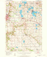 1950 Mankato East1950 Print · USGSBlue Earth County at mid-century reveals a dense network of rural school districts and rail sidings connecting farm towns to the regional hub. Researchers can trace the legacy of local education and industry through sites like Sugar Grove Sch, Lime Siding, and the St Clair settlement.3 unique versions available
 - 1951 Map of Mankato East
 1951 Mankato East1951 Print · USGSBlue Earth County's landscape in the early fifties is defined by its dense network of rural school districts and winding river valleys. Genealogists and historians can trace the foundations of local life at St Clair, Mankato Springs, and numerous family-named landmarks like Pugh Sch and Eagle Lake Cem.
 - 1953 Map of Saint Paul, 1964 Print
 1953 Saint Paul1964 Print · USGSThe Twin Cities and the Mississippi River valley are captured here at a mid-century turning point. Trace the early growth of Minneapolis and Saint Paul alongside landmarks like Lake Minnetonka and the St Croix River.4 unique versions available
 - 1959 Map of Saint Paul
 1959 Saint Paul1959 Print · USGSThe Twin Cities and southeastern Minnesota appear here in the late fifties, showing the peak of the rail era and post-war suburban growth. Genealogists can trace family footprints near Lake Minnetonka, the Univ Of Minn Rosemount Research Center, or the growing neighborhoods of Richfield.2 unique versions available
 - 1974 Map of Madison Lake, 1976 Print
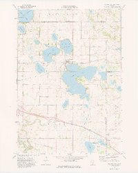 1974 Madison Lake1976 Print · USGSBlue Earth County’s lake country is captured here in the mid-seventies, showing the lakeside town of Madison Lake at a transitional moment. Genealogists and local historians can trace family locations near Marysburg, Smiths Mill, and the grounds of Calvary Cem.
 - 1974 Map of Mankato East, 1976 Print
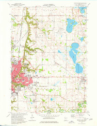 1974 Mankato East1976 Print · USGSMankato and its surrounding lake country are shown during a decade of collegiate and industrial growth in the mid-seventies. Researchers can locate numerous family burial sites at Calvary Cemetery and Sugar Grove Cem or trace the early paths of the Chicago and North Western railroad.2 unique versions available
 - 1985 Map of Faribault, 1986 Print
 1985 Faribault1986 Print · USGSThe Minnesota River valley and the glacial lake country of Rice and Le Sueur counties are shown here in the mid-1980s. Researchers can trace the academic grounds of St Olaf College or find old crossroads like Trondhjem and Little Chicago.2 unique versions available
End of results
Showing maps 1-7 of 7
Top cities near Eagle Lake
- Mankato historical maps
- North Mankato historical maps
- Saint Peter historical maps
- Le Center historical maps
- Janesville historical maps
- Rapidan historical maps
See more
Top neighborhoods of Eagle Lake
Frequently asked questions
- What are the different types of historical maps available for Eagle Lake?
- What is the oldest map of Eagle Lake?
- Where can I purchase historical maps of Eagle Lake for my home or office?
- Where can I download high-res historical maps of Eagle Lake?
- Are there historical topographic maps available for Eagle Lake?
- Is there historical aerial imagery available for Eagle Lake?
- Where are historical maps of Eagle Lake sourced from?