1980s Maps of Carlton County, Minnesota
Explore 13 historic maps of Carlton County from the 1980s. These maps offer a rare glimpse into what life looked like during the 1980s — showing old roads, neighborhoods, homes, and landmarks that have changed or disappeared over time.
Whether you're researching your family's past, planning a metal detecting trip, or studying how Carlton County's landscape evolved across the 1980s, these high-resolution maps are a powerful tool for exploring the history of this region.
- Focus on a specific era: All maps on this page are from the 1980s, giving you a focused view of this time period.
- See what’s changed: Compare century-old streets, trails, and buildings to today's modern landscape using overlays and satellite layers.
- Research with precision: Use these maps for genealogy, historical research, land use analysis, or educational projects.
- View, download, or print: Maps are fully viewable online in high resolution, and can be downloaded or printed for your own records.
Start exploring Carlton County's history through authentic maps from the 1980s. This is your window into the past.
Carlton County, MN maps
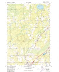
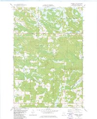
(13)- 1980 Map of Sandstone
 1980 Sandstone1980 Print · USGSPine County and the Minnesota-Wisconsin borderlands are shown here in the early eighties as a region of dense state forests and river corridors. Genealogists and historians can trace rail-town development along the Burlington Northern including Sandstone, Askov, and Hinckley.
 - 1980 Map of Duluth
 1980 Duluth1980 Print · USGSThe Twin Ports of the early 1980s showcase a landscape defined by heavy rail lines and Lake Superior shipping. Trace the iron-ore routes through Proctor or locate family sites near Sunrise Memorial Cem and Floodwood.
 - 1981 Map of Kettle River, 1982 Print
 1981 Kettle River1982 Print · USGSNear the border of Carlton and Pine counties in the early eighties, this area shows a landscape defined by its rivers and family-named roads. Genealogists can trace local heritage through landmarks like Nordland Cem, St Josephs Ch, and family routes like Greski Road.
 - 1981 Map of Hanging Horn Lake, 1982 Print
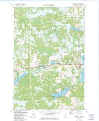
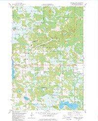
 1981 Hanging Horn Lake1982 Print · USGSBarnum and the surrounding lake country of Carlton and Pine Counties are captured here in the early 1980s. Researchers can trace local landmarks like Sunset Memorial Cem, the Drive-in Theater, and the Covered Bridge near Sturgeon Lake.
 - 1981 Map of Barnum, 1982 Print
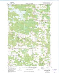
 1981 Barnum1982 Print · USGSCarlton County's rural landscape is captured here in the early eighties, centered on the rail-linked communities of Mahtowa and Barnum. Genealogists and local historians can trace family-named routes like Youngren Road or find sites like Salem Cem.
 - 1981 Map of Nickerson, 1982 Print
 1981 Nickerson1982 Print · USGSThe border of Carlton and Pine counties is captured in the early eighties as a hub of forestry and transit. Genealogists and local historians can trace family locations near Oak Lake Ch and Oak Lake Cem or follow the Burlington Northern rail line.
 - 1981 Map of Moose Lake, 1982 Print
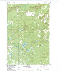
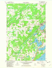 1981 Moose Lake1982 Print · USGSMoose Lake and the surrounding lake country of Carlton and Pine Counties are captured here in the early 1980s. Genealogists and local historians can locate the State Hospital, trace family roots at Finnish Cemetery, and explore the shoreline of Sturgeon Lake.
 - 1982 Map of Heikkila Creek
 1982 Heikkila Creek1982 Print · USGSCarlton County in the early eighties remains a landscape of river headwaters and township crossroads. Researchers can trace the Soo Line through the southern townships and locate family-named sites like West Branch Cem and Holy Trinity Cem.
 - 1982 Map of Cromwell West
 1982 Cromwell West1982 Print · USGSNorthern Minnesota wetlands and timberlands define this 1980s survey of Carlton County as the railroad era matured. Genealogists and historians can trace family-named routes like Krogh Road and locate rural landmarks such as Violet Cem and Eagle Lake.
 - 1982 Map of Cromwell SE
 1982 Cromwell SE1982 Print · USGSNortheastern Minnesota's wooded marshlands and river valleys are captured here in the early eighties. Genealogists and local historians can trace family-named roads like Granlund Road and locate sites like the Leonard Cem and the Kettle River.
 - 1982 Map of Cromwell East
 1982 Cromwell East1982 Print · USGSCarlton County's lake-strewn landscape is captured in the early 1980s, showcasing the transition between small-town life and the vast Fond Du Lac State Forest. Genealogists and historians can trace family road names like Homstad Road and locate landmarks like the Cromwell Lookout Tower or the Burlington Northern rail line.
 - 1983 Map of Holyoke
 1983 Holyoke1983 Print · USGSThe Minnesota-Wisconsin borderlands appear here in the early eighties as a dense network of timber and wetlands within the Nemadji State Forest. You can trace the path of the Burlington Northern rail line or locate local landmarks like the Cem at Nickerson and the Old Grade.
 - 1985 Map of Mille Lacs Lake
 1985 Mille Lacs Lake1985 Print · USGSMille Lacs Lake and its surrounding settlements are shown in the mid-1980s as a hub of lake-shore recreation and rail commerce. Researchers can trace historic transport lines like the Soo Line and locate communities such as Wahkon and Garrison.2 unique versions available
End of results
Showing maps 1-13 of 13
Top cities of Carlton County
- Cloquet historical maps
- Moose Lake historical maps
- Scanlon historical maps
- Carlton historical maps
- Barnum historical maps
- Wrenshall historical maps
See more
Frequently asked questions
- What are the different types of historical maps available for Carlton County?
- What is the oldest map of Carlton County?
- Where can I purchase historical maps of Carlton County for my home or office?
- Where can I download high-res historical maps of Carlton County?
- Are there historical topographic maps available for Carlton County?
- Is there historical aerial imagery available for Carlton County?
- Where are historical maps of Carlton County sourced from?