
1980 Map of Sandstone
USGS Topo · Published 1980About this map
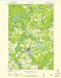
The Kettle River and St Croix River systems define the geography of this Pine County region as it appeared in 1980. This survey illustrates the dense concentration of public lands across the Minnesota and Wisconsin border, including the expansive Nemadji State Forest and the St Croix National Scenic Riverway. In the west, the Burlington Northern and Northern Pacific rail lines serve established rail-corridor towns like Hinckley, Sandstone, and Askov.
Find a feature on this map
78 named features on this map. Tap any name to fly to it.
Don’t see what you’re looking for? This feature index may not catch every label — zoom into the map to look around manually.
Map Details
Editions of this 1980 Sandstone Map
This is the sole edition of this map. No revisions or reprints were ever made.
Other maps of this area

1915 · Superior
USGS Topo · 1:48,000

1917 · Superior
USGS Topo · 1:62,500

1945 · Solon Springs
USGS Topo · 1:48,000

1947 · Minong
USGS Topo · 1:48,000
1948 · Spooner
USGS Topo · 1:48,000

1949 · Danbury
USGS Topo · 1:48,000

1949 · Solon Springs
USGS Topo · 1:48,000

1949 · Hertel
USGS Topo · 1:48,000

1949 · Holyoke
USGS Topo · 1:48,000

1949 · Minong
USGS Topo · 1:48,000