
1947 Map of Minong
USGS Topo · Published 1964About this map
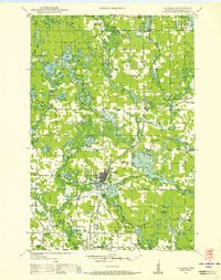
The St Croix Flowage and the upper reaches of the St Croix River define the northern boundary of this 1947 field survey, where the water-rich landscape of northwest Wisconsin is captured before modern development. The region's transport network is anchored by U S Highway 53 and the Chicago St Paul Minneapolis and Omaha Ry, which run parallel through the glacial terrain. Local life in Minong and Wascott is detailed through the location of essential community structures, including the Wascott Ch and rural education centers like Hoover Sch and Whittier Sch. The map reveals an intricate mosaic of lakes and wetlands, such as the Cranberry Bog and the extensive Lake Nancy Flowage, illustrating a landscape shaped by both natural hydrology and early 20th-century water management for the timber and recreation industries.
Find a feature on this map
80 named features on this map. Tap any name to fly to it.
Don’t see what you’re looking for? This feature index may not catch every label — zoom into the map to look around manually.
Map Details
Editions of this 1947 Minong Map
This is the sole edition of this map. No revisions or reprints were ever made.
Other maps of this area

1945 · Highland
USGS Topo · 1:48,000

1945 · Solon Springs
USGS Topo · 1:48,000

1947 · Chittamo
USGS Topo · 1:48,000
1948 · Spooner
USGS Topo · 1:48,000
1948 · Stone Lake
USGS Topo · 1:48,000

1949 · Solon Springs
USGS Topo · 1:48,000

1949 · Chittamo
USGS Topo · 1:48,000

1949 · Hertel
USGS Topo · 1:48,000

1949 · Minong
USGS Topo · 1:48,000

1949 · Webb Lake
USGS Topo · 1:48,000