
1949 Map of Danbury
USGS Topo · Published 1949About this map
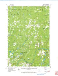
The St Croix River defines the border between Minnesota and Wisconsin in this mid-century survey, which reveals a landscape dominated by timber and water at the edge of an extensive Unsurveyed Area. The settlement of Danbury serves as the local hub near the confluence of the Yellow River, while narrow strips of development follow State Highway No 35. Much of the terrain remains marshy or wooded, punctuated by family-named landmarks and rural infrastructure. Local education is anchored by the Atkinson Sch and Stevens Sch, while the presence of the Minerva Dam and an Emergency Landing Field highlights the era's utility and transportation needs. The map captures a detailed view of the regional hydrology, from the Upper Tamarack River in the north to the cluster of lakes including Tabor Lake, Burlingame Lake, and Staples L further south.
Find a feature on this map
24 named features on this map. Tap any name to fly to it.
Don’t see what you’re looking for? This feature index may not catch every label — zoom into the map to look around manually.
Map Details
Editions of this 1949 Danbury Map
This is the sole edition of this map. No revisions or reprints were ever made.
Historical Maps of Dairyland Through Time
Featured Locations
- Arna Township, MN
- Dairyland, WI
- Kingsdale, New Dosey Township
- Cloverton, New Dosey Township
- Markville, Arna Township