1960s Maps of Hitterdal, Minnesota
Explore 2 historic maps of Hitterdal from the 1960s. These maps offer a rare glimpse into what life looked like during the 1960s — showing old roads, neighborhoods, homes, and landmarks that have changed or disappeared over time.
Whether you're researching your family's past, planning a metal detecting trip, or studying how Hitterdal's landscape evolved across the 1960s, these high-resolution maps are a powerful tool for exploring the history of this region.
- Focus on a specific era: All maps on this page are from the 1960s, giving you a focused view of this time period.
- See what’s changed: Compare century-old streets, trails, and buildings to today's modern landscape using overlays and satellite layers.
- Research with precision: Use these maps for genealogy, historical research, land use analysis, or educational projects.
- View, download, or print: Maps are fully viewable online in high resolution, and can be downloaded or printed for your own records.
Start exploring Hitterdal's history through authentic maps from the 1960s. This is your window into the past.
Hitterdal, MN maps
(2)- 1966 Map of Dale, 1967 Print
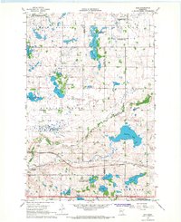 1966 Dale1967 Print · USGSRailroad hubs and prairie wetlands converge in Clay County during the mid-sixties, capturing the height of the regional rail network. Genealogists and historians can trace the foundations of local life at Manitoba Junction, Dale, and the Highland Grove Ch.
 - 1966 Map of Hawley, 1967 Print
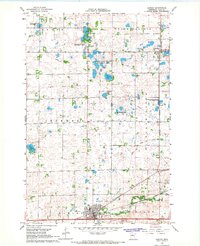 1966 Hawley1967 Print · USGSClay County at the height of the 1960s shows a landscape of prairie townships and rail-oriented commerce. Local researchers can trace family landmarks like Cem Lysne Ch and the Northern Pacific line running through Hitterdal and Hawley.
End of results
Showing maps 1-2 of 2
Top cities near Hitterdal
Frequently asked questions
- What are the different types of historical maps available for Hitterdal?
- What is the oldest map of Hitterdal?
- Where can I purchase historical maps of Hitterdal for my home or office?
- Where can I download high-res historical maps of Hitterdal?
- Are there historical topographic maps available for Hitterdal?
- Is there historical aerial imagery available for Hitterdal?
- Where are historical maps of Hitterdal sourced from?