1960s Maps of Moorhead, Minnesota
Explore 2 historic maps of Moorhead from the 1960s. These maps offer a rare glimpse into what life looked like during the 1960s — showing old roads, neighborhoods, homes, and landmarks that have changed or disappeared over time.
Whether you're researching your family's past, planning a metal detecting trip, or studying how Moorhead's landscape evolved across the 1960s, these high-resolution maps are a powerful tool for exploring the history of this region.
- Focus on a specific era: All maps on this page are from the 1960s, giving you a focused view of this time period.
- See what’s changed: Compare century-old streets, trails, and buildings to today's modern landscape using overlays and satellite layers.
- Research with precision: Use these maps for genealogy, historical research, land use analysis, or educational projects.
- View, download, or print: Maps are fully viewable online in high resolution, and can be downloaded or printed for your own records.
Start exploring Moorhead's history through authentic maps from the 1960s. This is your window into the past.
Moorhead, MN maps
(2)- 1964 Map of Sabin, 1966 Print
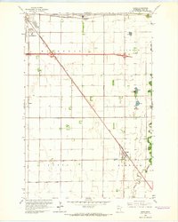 1964 Sabin1966 Print · USGSClay County in the mid-1960s is shown here as a landscape of rail-driven settlements and vital drainage works. You can trace the path of the Northern Pacific through Sabin or locate early landmarks like the Moorhead Airport and the local Dragstrip.3 unique versions available
 - 1964 Map of Dilworth, 1966 Print
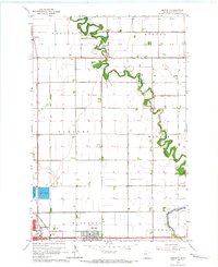 1964 Dilworth1966 Print · USGSClay County at the height of the mid-century rail era shows a landscape shaped by the winding Buffalo River and the expanding town of Dilworth. Researchers can trace the local rail networks through Kragnes and locate family homesteads along the rural sectional roads.3 unique versions available
End of results
Showing maps 1-2 of 2
Top cities near Moorhead
- Fargo historical maps
- West Fargo historical maps
- Dilworth historical maps
- Horace historical maps
- Glyndon historical maps
- Harwood historical maps
See more
Top neighborhoods of Moorhead
- McCann's 1st Subdivision historical maps
- North Crystal Creek 1st Subdivision historical maps
- Oelke's historical maps
- Replat L10 B1 Brentwood Acres historical maps
- Rolyn Acres historical maps
- Brentwood Acres 2nd Addition historical maps
See more
Frequently asked questions
- What are the different types of historical maps available for Moorhead?
- What is the oldest map of Moorhead?
- Where can I purchase historical maps of Moorhead for my home or office?
- Where can I download high-res historical maps of Moorhead?
- Are there historical topographic maps available for Moorhead?
- Is there historical aerial imagery available for Moorhead?
- Where are historical maps of Moorhead sourced from?