1900s (20th Century) Maps of Pigeon River, Minnesota
Explore 5 historic maps of Pigeon River from the 1900s (20th Century). These maps offer a rare glimpse into what life looked like during the 1900s — showing old roads, neighborhoods, homes, and landmarks that have changed or disappeared over time.
Whether you're researching your family's past, planning a metal detecting trip, or studying how Pigeon River's landscape evolved across the 1900s, these high-resolution maps are a powerful tool for exploring the history of this region.
- Focus on a specific era: All maps on this page are from the 1900s, giving you a focused view of this time period.
- See what’s changed: Compare century-old streets, trails, and buildings to today's modern landscape using overlays and satellite layers.
- Research with precision: Use these maps for genealogy, historical research, land use analysis, or educational projects.
- View, download, or print: Maps are fully viewable online in high resolution, and can be downloaded or printed for your own records.
Start exploring Pigeon River's history through authentic maps from the 1900s. This is your window into the past.
Pigeon River, MN maps
(5)- 1959 Map of Fort William, 1967 Print
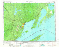 1959 Fort William1967 Print · USGSThe northern shore of Lake Superior at the close of the 1950s shows a thriving rail and shipping network connecting the twin ports and the remote island wilderness. Trace family roots and local industry in Port Arthur, Vickers Heights, and Isle Royale National Park.3 unique versions available
 - 1959 Map of Grand Portage, 1967 Print
 1959 Grand Portage1967 Print · USGSThe North Shore of Lake Superior meets the Canadian border in the late fifties, where the historic Grand Portage trail remains a central landmark. Researchers can locate the early layout of Grand Portage, the Pagan Cem, and landmarks like Mt Rose and Grand Portage Island.2 unique versions available
 - 1968 Map of Fort William
 1968 Fort William1968 Print · USGSThe Canadian Lakehead and Isle Royale appear here in the late sixties, just before Port Arthur and Fort William merged. Genealogists can locate family lands near Rosslyn Village, Silver Mountain, and the Fort William Indian Reserve 52.
 - 1985 Map of Pigeon Point
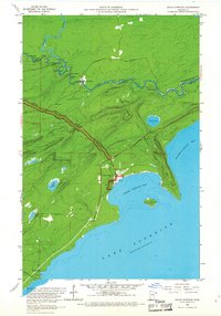
 1985 Pigeon Point1985 Print · USGSThe Minnesota-Canada borderlands meet Lake Superior in the mid-1980s at this remote northern tip of Cook County. Researchers can trace the international line along the Pigeon River and explore the coastal boundaries of Grand Portage State Forest and Isle Royale National Park.2 unique versions available
 - 1999 Map of Grand Portage, 2003 Print
 1999 Grand Portage2003 Print · USGSThe northern reaches of the Arrowhead Region come into focus at the turn of the millennium, centered on the ancient fur trade corridor. Local researchers can trace the Grand Portage National Monument and locate landmarks like Pagan Cem or the Lookout Tower near the village of Grand Portage.
End of results
Showing maps 1-5 of 5
Top cities near Pigeon River
Frequently asked questions
- What are the different types of historical maps available for Pigeon River?
- What is the oldest map of Pigeon River?
- Where can I purchase historical maps of Pigeon River for my home or office?
- Where can I download high-res historical maps of Pigeon River?
- Are there historical topographic maps available for Pigeon River?
- Is there historical aerial imagery available for Pigeon River?
- Where are historical maps of Pigeon River sourced from?