1970s Maps of Randolph Township, Minnesota
Explore 2 historic maps of Randolph Township from the 1970s. These maps offer a rare glimpse into what life looked like during the 1970s — showing old roads, neighborhoods, homes, and landmarks that have changed or disappeared over time.
Whether you're researching your family's past, planning a metal detecting trip, or studying how Randolph Township's landscape evolved across the 1970s, these high-resolution maps are a powerful tool for exploring the history of this region.
- Focus on a specific era: All maps on this page are from the 1970s, giving you a focused view of this time period.
- See what’s changed: Compare century-old streets, trails, and buildings to today's modern landscape using overlays and satellite layers.
- Research with precision: Use these maps for genealogy, historical research, land use analysis, or educational projects.
- View, download, or print: Maps are fully viewable online in high resolution, and can be downloaded or printed for your own records.
Start exploring Randolph Township's history through authentic maps from the 1970s. This is your window into the past.
Randolph Township, MN maps
(2)- 1974 Map of Randolph, 1976 Print
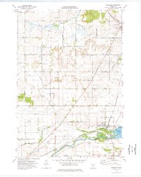 1974 Randolph1976 Print · USGSDakota and Goodhue Counties come alive in this mid-seventies survey, featuring the agricultural heartland during a period of steady rural development. Genealogists can trace family footprints through numerous local sites like Redrose Cem, Castle Rock, and the rail junction at Randolph.
 - 1974 Map of Cannon Falls, 1978 Print
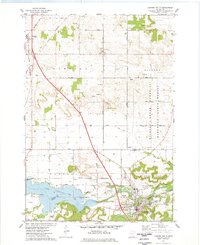 1974 Cannon Falls1978 Print · USGSThe confluence of the Cannon River and Spring Creek defines this area during the mid-seventies, showing the growth of Cannon Falls. Trace the historic Chicago and North Western rail line past Zion Cem and the small settlement of New Trier.
End of results
Showing maps 1-2 of 2
Top cities near Randolph Township
- Lakeville historical maps
- Apple Valley historical maps
- Hastings historical maps
- Rosemount historical maps
- Northfield historical maps
- Farmington historical maps
See more
Frequently asked questions
- What are the different types of historical maps available for Randolph Township?
- What is the oldest map of Randolph Township?
- Where can I purchase historical maps of Randolph Township for my home or office?
- Where can I download high-res historical maps of Randolph Township?
- Are there historical topographic maps available for Randolph Township?
- Is there historical aerial imagery available for Randolph Township?
- Where are historical maps of Randolph Township sourced from?