1990s Maps of Etter, Ravenna Township
Explore 2 historic maps of Etter from the 1990s. These maps offer a rare glimpse into what life looked like during the 1990s — showing old roads, neighborhoods, homes, and landmarks that have changed or disappeared over time.
Whether you're researching your family's past, planning a metal detecting trip, or studying how Etter's landscape evolved across the 1990s, these high-resolution maps are a powerful tool for exploring the history of this region.
- Focus on a specific era: All maps on this page are from the 1990s, giving you a focused view of this time period.
- See what’s changed: Compare century-old streets, trails, and buildings to today's modern landscape using overlays and satellite layers.
- Research with precision: Use these maps for genealogy, historical research, land use analysis, or educational projects.
- View, download, or print: Maps are fully viewable online in high resolution, and can be downloaded or printed for your own records.
Start exploring Etter's history through authentic maps from the 1990s. This is your window into the past.
Etter, Ravenna Township maps
(2)- 1990 Map of Hastings, 1991 Print
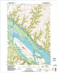
 1990 Hastings1991 Print · USGSThe river confluence at Hastings and Prescott is captured here in the final decade of the twentieth century, showing a landscape defined by the Mississippi River and St Croix River. Genealogists and historians can trace rail corridors like the Soo RR and find smaller settlements such as Miesville, Wacouta, and Diamond Bluff.
 - 1992 Map of Diamond Bluff West, 1995 Print
 1992 Diamond Bluff West1995 Print · USGSThe Mississippi River valley near the Wisconsin border appears here in the early nineties, revealing a complex network of sloughs and backwater lakes. Genealogists and river historians can locate Smith Landing, the Prairie Island Cem, and landmarks like Welch Prairie.
End of results
Showing maps 1-2 of 2
Top cities near Etter
- Woodbury historical maps
- Cottage Grove historical maps
- Hastings historical maps
- Red Wing historical maps
- River Falls historical maps
- Prescott historical maps
See more
Frequently asked questions
- What are the different types of historical maps available for Etter?
- What is the oldest map of Etter?
- Where can I purchase historical maps of Etter for my home or office?
- Where can I download high-res historical maps of Etter?
- Are there historical topographic maps available for Etter?
- Is there historical aerial imagery available for Etter?
- Where are historical maps of Etter sourced from?