
1990 Map of Hastings
USGS Topo · Published 1991About this map
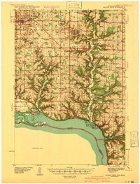
The confluence of the Mississippi River and the St Croix River serves as the focal point for this 1990 survey, showing the intricate boundary lands of Minnesota and Wisconsin. At the heart of the waterway network lies Prescott and Hastings, where the river systems dictate the layout of timbered bluffs and fertile bottomlands. The landscape is defined by its massive water features, including the expansion of Lake St Croix to the north and the wide reach of Lake Pepin to the southeast.
Find a feature on this map
82 named features on this map. Tap any name to fly to it.
Don’t see what you’re looking for? This feature index may not catch every label — zoom into the map to look around manually.
Map Details
Editions of this 1990 Hastings Map
This is the sole edition of this map. No revisions or reprints were ever made.
Other maps of this area

1896 · St. Paul
USGS Topo · 1:62,500

1902 · White Bear
USGS Topo · 1:62,500

1929 · Durand
USGS Topo · 1:62,500

1932 · Wabasha
USGS Topo · 1:62,500

1932 · Durand
USGS Topo · 1:62,500

1932 · Alma
USGS Topo · 1:62,500

1935 · Arkansaw
USGS Topo · 1:48,000
1940 · Maiden Rock
USGS Topo · 1:62,500

1940 · Menomonie
USGS Topo · 1:62,500

1941 · Arkansaw
USGS Topo · 1:62,500