
1941 Map of Arkansaw
USGS Topo · Published 1941About this map
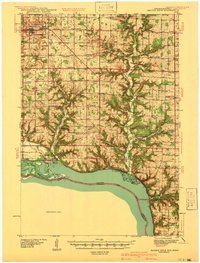
The Chippewa River corridor and the deeply etched coulees of the Driftless Area define this landscape at the start of the 1940s. The village of Arkansaw serves as a hub near the confluence of Arkansaw Creek and the Eau Galle River, while the Chicago Milwaukee St Paul and Pacific railroad traces the eastern bank of the Chippewa. The map reveals an intricate network of rural education and faith, with dozens of institutions like Poplar Grove Sch, St Joseph Ch, and the Lund Sch serving dispersed farming families. Geologic features such as The Hogback and Eau Galle Mound rise above the river bottomlands, while Buffalo Island sits between the main river channel and Buffalo Slough. This survey captures the transition from small hamlets like Exile and Nerike toward the consolidated agricultural region of modern Pepin County.
Find a feature on this map
115 named features on this map. Tap any name to fly to it.
Don’t see what you’re looking for? This feature index may not catch every label — zoom into the map to look around manually.
Map Details
Editions of this 1941 Arkansaw Map
This is the sole edition of this map. No revisions or reprints were ever made.
Other maps of this area

1929 · Durand
USGS Topo · 1:62,500

1932 · Wabasha
USGS Topo · 1:62,500

1932 · Durand
USGS Topo · 1:62,500

1932 · Alma
USGS Topo · 1:62,500

1935 · Arkansaw
USGS Topo · 1:48,000
1940 · Maiden Rock
USGS Topo · 1:62,500

1940 · Menomonie
USGS Topo · 1:62,500

1942 · Arkansaw
USGS Topo · 1:62,500

1942 · Menomonie
USGS Topo · 1:62,500

1946 · Knapp
USGS Topo · 1:62,500