
1946 Map of Knapp
USGS Topo · Published 1967About this map
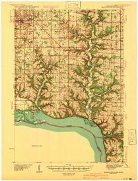
The Chicago St Paul Minneapolis and Omaha railroad line cuts through the northern half of this landscape, connecting the communities of Hersey and Knapp as it follows the valley of Wilson Creek. This 1940s survey reveals a dense network of country schools, such as Summit Sch, Miller Hill Sch, and Nippersink Sch, which served the rural farmsteads across the borders of St. Croix, Pierce, and Dunn Counties. The terrain is defined by several prominent ridges, including Highland Ridge and Morton Hill, which separate the various drainages of the Eau Galle River system.
Find a feature on this map
61 named features on this map. Tap any name to fly to it.
Don’t see what you’re looking for? This feature index may not catch every label — zoom into the map to look around manually.
Map Details
Editions of this 1946 Knapp Map
This is the sole edition of this map. No revisions or reprints were ever made.
Other maps of this area

1929 · Durand
USGS Topo · 1:62,500

1932 · Durand
USGS Topo · 1:62,500

1935 · Arkansaw
USGS Topo · 1:48,000
1940 · Maiden Rock
USGS Topo · 1:62,500

1940 · Menomonie
USGS Topo · 1:62,500

1941 · Arkansaw
USGS Topo · 1:62,500

1942 · Arkansaw
USGS Topo · 1:62,500

1942 · Menomonie
USGS Topo · 1:62,500

1948 · Downing
USGS Topo · 1:62,500

1949 · Knapp
USGS Topo · 1:62,500