
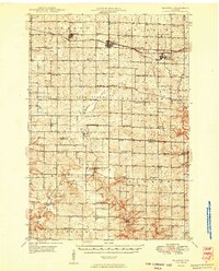
1948 Map of Downing
USGS Topo · Published 1970About this map
The Minneapolis St Paul and Sault Ste Marie corridor anchors the southern half of this mid-century survey, connecting the villages of Glenwood, Downing, and Boyceville. This rail-and-water network defines the local geography, where Tiffany Creek and the Hay River meet the tracks amidst a dense distribution of rural one-room schoolhouses. Notable educational sites like Beaver Valley Sch and Maple Ridge Sch speak to the dispersed agricultural population of the late 1940s.
Find a feature on this map
64 named features on this map. Tap any name to fly to it.
Don’t see what you’re looking for? This feature index may not catch every label — zoom into the map to look around manually.
Map Details
Editions of this 1948 Downing Map
This is the sole edition of this map. No revisions or reprints were ever made.
Other maps of this area

1940 · Menomonie
USGS Topo · 1:62,500

1942 · Menomonie
USGS Topo · 1:62,500

1946 · Knapp
USGS Topo · 1:62,500

1949 · Knapp
USGS Topo · 1:62,500
1949 · Baldwin
USGS Topo · 1:62,500
1949 · Ridgeland
USGS Topo · 1:62,500

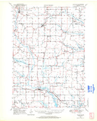
1950 · Downing
USGS Topo · 1:62,500
1950 · Deer Park
USGS Topo · 1:62,500

1950 · Balsam Lake
USGS Topo · 1:62,500
1950 · Turtle Lake
USGS Topo · 1:62,500