1970s Maps of Dodge County, Minnesota
Explore 2 historic maps of Dodge County from the 1970s. These maps offer a rare glimpse into what life looked like during the 1970s — showing old roads, neighborhoods, homes, and landmarks that have changed or disappeared over time.
Whether you're researching your family's past, planning a metal detecting trip, or studying how Dodge County's landscape evolved across the 1970s, these high-resolution maps are a powerful tool for exploring the history of this region.
- Focus on a specific era: All maps on this page are from the 1970s, giving you a focused view of this time period.
- See what’s changed: Compare century-old streets, trails, and buildings to today's modern landscape using overlays and satellite layers.
- Research with precision: Use these maps for genealogy, historical research, land use analysis, or educational projects.
- View, download, or print: Maps are fully viewable online in high resolution, and can be downloaded or printed for your own records.
Start exploring Dodge County's history through authentic maps from the 1970s. This is your window into the past.
Dodge County, MN maps
(2)- 1974 Map of Rock Dell, 1976 Print
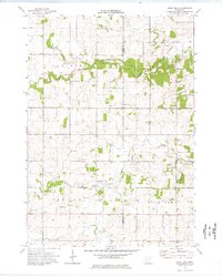 1974 Rock Dell1976 Print · USGSDodge and Olmsted Counties come into focus during the mid-1970s as agricultural patterns and small rural settlements define the landscape. Researchers can trace local history through sites like East St Olaf Ch, the South Zumbro Ch, and the hamlet of Shanty Town.
 - 1974 Map of High Forest SW, 1976 Print
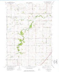 1974 High Forest SW1976 Print · USGSMower County and the surrounding townships are captured in the mid-seventies, showing a landscape defined by the winding Root River. Researchers can trace rural community life through landmarks like Evanger Ch, Zion Ch, and the local Townhall.
End of results
Showing maps 1-2 of 2
Top cities of Dodge County
- Kasson historical maps
- Dodge Center historical maps
- Hayfield historical maps
- Mantorville historical maps
- West Concord historical maps
- Concord historical maps
See more
Frequently asked questions
- What are the different types of historical maps available for Dodge County?
- What is the oldest map of Dodge County?
- Where can I purchase historical maps of Dodge County for my home or office?
- Where can I download high-res historical maps of Dodge County?
- Are there historical topographic maps available for Dodge County?
- Is there historical aerial imagery available for Dodge County?
- Where are historical maps of Dodge County sourced from?