1960s Maps of Minnesota Lake, Minnesota
Explore 1 historic maps of Minnesota Lake from the 1960s. These maps offer a rare glimpse into what life looked like during the 1960s — showing old roads, neighborhoods, homes, and landmarks that have changed or disappeared over time.
Whether you're researching your family's past, planning a metal detecting trip, or studying how Minnesota Lake's landscape evolved across the 1960s, these high-resolution maps are a powerful tool for exploring the history of this region.
- Focus on a specific era: All maps on this page are from the 1960s, giving you a focused view of this time period.
- See what’s changed: Compare century-old streets, trails, and buildings to today's modern landscape using overlays and satellite layers.
- Research with precision: Use these maps for genealogy, historical research, land use analysis, or educational projects.
- View, download, or print: Maps are fully viewable online in high resolution, and can be downloaded or printed for your own records.
Start exploring Minnesota Lake's history through authentic maps from the 1960s. This is your window into the past.
Minnesota Lake, MN maps
(1)- 1967 Map of Minnesota Lake, 1968 Print
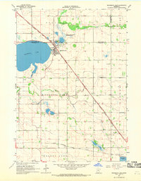 1967 Minnesota Lake1968 Print · USGSMinnesota Lake and its surrounding townships are captured in the late sixties as the local rail and agricultural systems remained firmly established. Genealogists and historians can trace family plots at Peace Cem or Zions Cem and locate landmarks like the Stokman State Wildlife Management Area.2 unique versions available
End of results
Showing maps 1-1 of 1
Top cities near Minnesota Lake
- Wells historical maps
- Mapleton historical maps
- Beauford historical maps
- Pemberton historical maps
- Waldorf historical maps
- Brush Creek historical maps
See more
Frequently asked questions
- What are the different types of historical maps available for Minnesota Lake?
- What is the oldest map of Minnesota Lake?
- Where can I purchase historical maps of Minnesota Lake for my home or office?
- Where can I download high-res historical maps of Minnesota Lake?
- Are there historical topographic maps available for Minnesota Lake?
- Is there historical aerial imagery available for Minnesota Lake?
- Where are historical maps of Minnesota Lake sourced from?