1960s Maps of Kenyon Township, Minnesota
Explore 4 historic maps of Kenyon Township from the 1960s. These maps offer a rare glimpse into what life looked like during the 1960s — showing old roads, neighborhoods, homes, and landmarks that have changed or disappeared over time.
Whether you're researching your family's past, planning a metal detecting trip, or studying how Kenyon Township's landscape evolved across the 1960s, these high-resolution maps are a powerful tool for exploring the history of this region.
- Focus on a specific era: All maps on this page are from the 1960s, giving you a focused view of this time period.
- See what’s changed: Compare century-old streets, trails, and buildings to today's modern landscape using overlays and satellite layers.
- Research with precision: Use these maps for genealogy, historical research, land use analysis, or educational projects.
- View, download, or print: Maps are fully viewable online in high resolution, and can be downloaded or printed for your own records.
Start exploring Kenyon Township's history through authentic maps from the 1960s. This is your window into the past.
Kenyon Township, MN maps
(4)- 1960 Map of Nerstrand, 1961 Print
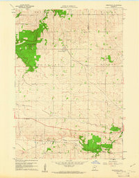 1960 Nerstrand1961 Print · USGSSoutheastern Minnesota farmland at the start of the 1960s reveals a landscape of rural churches and competing rail lines. Local historians can trace family roots at Valley Grove Ch, explore the village of Nerstrand, or locate old sites near Falls Creek.2 unique versions available
 - 1962 Map of Moland, 1964 Print
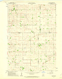 1962 Moland1964 Print · USGSSteele and Rice counties are captured in the early sixties, showing a landscape of established farmsteads and rural social hubs. Genealogists can locate Richland Center, the Merton Cem, and the community surrounding Moland Ch.2 unique versions available
 - 1965 Map of West Concord, 1966 Print
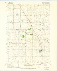 1965 West Concord1966 Print · USGSDodge County farmland was defined by its rails and rivers in the mid-sixties, with the Chicago Great Western railroad serving as a vital corridor. Genealogists can locate family landmarks like Hegre Ch Cem and the small settlement of Skyberg near the Goodhue County line.
 - 1968 Map of Kenyon, 1970 Print
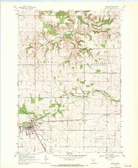 1968 Kenyon1970 Print · USGSKenyon and the surrounding Goodhue County townships are captured in the late 1960s at a peak of rail activity. Genealogists can trace family sites at Wangs Cem and St Michaels Cem or locate the old Nansen and Bombay settlements.2 unique versions available
End of results
Showing maps 1-4 of 4
Top cities near Kenyon Township
- Owatonna historical maps
- Northfield historical maps
- Kasson historical maps
- Dodge Center historical maps
- Kenyon historical maps
- Mantorville historical maps
See more
Top neighborhoods of Kenyon Township
Frequently asked questions
- What are the different types of historical maps available for Kenyon Township?
- What is the oldest map of Kenyon Township?
- Where can I purchase historical maps of Kenyon Township for my home or office?
- Where can I download high-res historical maps of Kenyon Township?
- Are there historical topographic maps available for Kenyon Township?
- Is there historical aerial imagery available for Kenyon Township?
- Where are historical maps of Kenyon Township sourced from?