1960s Maps of Roscoe Township, Minnesota
Explore 4 historic maps of Roscoe Township from the 1960s. These maps offer a rare glimpse into what life looked like during the 1960s — showing old roads, neighborhoods, homes, and landmarks that have changed or disappeared over time.
Whether you're researching your family's past, planning a metal detecting trip, or studying how Roscoe Township's landscape evolved across the 1960s, these high-resolution maps are a powerful tool for exploring the history of this region.
- Focus on a specific era: All maps on this page are from the 1960s, giving you a focused view of this time period.
- See what’s changed: Compare century-old streets, trails, and buildings to today's modern landscape using overlays and satellite layers.
- Research with precision: Use these maps for genealogy, historical research, land use analysis, or educational projects.
- View, download, or print: Maps are fully viewable online in high resolution, and can be downloaded or printed for your own records.
Start exploring Roscoe Township's history through authentic maps from the 1960s. This is your window into the past.
Roscoe Township, MN maps
(4)- 1965 Map of Concord, 1966 Print
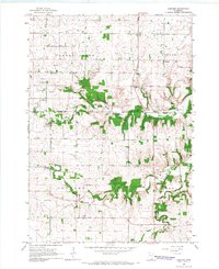 1965 Concord1966 Print · USGSThe rural countryside of Dodge and Goodhue counties comes into focus in the mid-1960s, showing a landscape defined by the Zumbro River. Trace old homesteads near Berne, Roscoe, and the rural St Rose Ch or Riverside Cem.2 unique versions available
 - 1965 Map of Pine Island, 1967 Print
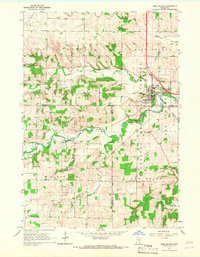 1965 Pine Island1967 Print · USGSPine Island and the surrounding agricultural townships are seen here in the mid-1960s as the rail and river networks shaped the region. Genealogists and local historians can locate early burial sites like St Michael Cem and follow the Chicago Great Western tracks.2 unique versions available
 - 1968 Map of Zumbrota, 1970 Print
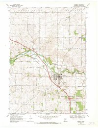 1968 Zumbrota1970 Print · USGSZumbrota and its surrounding townships are captured in the late sixties as the region's rail and agricultural patterns remained clearly defined. Genealogists and local historians can trace legacy sites like St Johns Ch, United Cem, and the small community of Forest Mills.2 unique versions available
 - 1968 Map of Wanamingo, 1970 Print
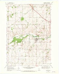 1968 Wanamingo1970 Print · USGSGoodhue County comes into focus in the late sixties as the rail-and-river economy centers on the town of Wanamingo. Local historians can trace family ties at Trinity Cem and Dale Cem, or follow the Chicago Milwaukee St Paul and Pacific railroad through the valley.2 unique versions available
End of results
Showing maps 1-4 of 4
Top cities near Roscoe Township
- Rochester historical maps
- Kasson historical maps
- Byron historical maps
- Pine Island historical maps
- Zumbrota historical maps
- Dodge Center historical maps
See more
Top neighborhoods of Roscoe Township
Frequently asked questions
- What are the different types of historical maps available for Roscoe Township?
- What is the oldest map of Roscoe Township?
- Where can I purchase historical maps of Roscoe Township for my home or office?
- Where can I download high-res historical maps of Roscoe Township?
- Are there historical topographic maps available for Roscoe Township?
- Is there historical aerial imagery available for Roscoe Township?
- Where are historical maps of Roscoe Township sourced from?