1980s Maps of Hubbard County, Minnesota
Explore 2 historic maps of Hubbard County from the 1980s. These maps offer a rare glimpse into what life looked like during the 1980s — showing old roads, neighborhoods, homes, and landmarks that have changed or disappeared over time.
Whether you're researching your family's past, planning a metal detecting trip, or studying how Hubbard County's landscape evolved across the 1980s, these high-resolution maps are a powerful tool for exploring the history of this region.
- Focus on a specific era: All maps on this page are from the 1980s, giving you a focused view of this time period.
- See what’s changed: Compare century-old streets, trails, and buildings to today's modern landscape using overlays and satellite layers.
- Research with precision: Use these maps for genealogy, historical research, land use analysis, or educational projects.
- View, download, or print: Maps are fully viewable online in high resolution, and can be downloaded or printed for your own records.
Start exploring Hubbard County's history through authentic maps from the 1980s. This is your window into the past.
Hubbard County, MN maps
(2)- 1985 Map of Lake Itasca
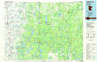 1985 Lake Itasca1985 Print · USGSNorthwestern Minnesota’s forest and lake country is captured here in the mid-1980s, centered on the White Earth Indian Reservation. Researchers can trace the Burlington Northern line and locate local landmarks like Elbow Lake Village, Naytahwaush, and Itasca State Park.2 unique versions available
 - 1986 Map of Detroit Lakes
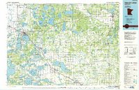 1986 Detroit Lakes1986 Print · USGSBecker and Otter Tail counties in the 1980s reveal a landscape of vast wildlife refuges and glacial lakes. Genealogists and historians can trace the rail corridor through Detroit Lakes and Perham or locate family sites near Sugar Bush Lake and Smoky Hill Lookout.2 unique versions available
End of results
Showing maps 1-2 of 2
Top cities of Hubbard County
- Park Rapids historical maps
- Arago historical maps
- Guthrie historical maps
- Akeley historical maps
- Nevis historical maps
- Lake George historical maps
See more
Frequently asked questions
- What are the different types of historical maps available for Hubbard County?
- What is the oldest map of Hubbard County?
- Where can I purchase historical maps of Hubbard County for my home or office?
- Where can I download high-res historical maps of Hubbard County?
- Are there historical topographic maps available for Hubbard County?
- Is there historical aerial imagery available for Hubbard County?
- Where are historical maps of Hubbard County sourced from?