1980s Maps of Isanti, Minnesota
Explore 3 historic maps of Isanti from the 1980s. These maps offer a rare glimpse into what life looked like during the 1980s — showing old roads, neighborhoods, homes, and landmarks that have changed or disappeared over time.
Whether you're researching your family's past, planning a metal detecting trip, or studying how Isanti's landscape evolved across the 1980s, these high-resolution maps are a powerful tool for exploring the history of this region.
- Focus on a specific era: All maps on this page are from the 1980s, giving you a focused view of this time period.
- See what’s changed: Compare century-old streets, trails, and buildings to today's modern landscape using overlays and satellite layers.
- Research with precision: Use these maps for genealogy, historical research, land use analysis, or educational projects.
- View, download, or print: Maps are fully viewable online in high resolution, and can be downloaded or printed for your own records.
Start exploring Isanti's history through authentic maps from the 1980s. This is your window into the past.
Isanti, MN maps
(3)- 1983 Map of Cambridge, 1984 Print
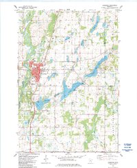 1983 Cambridge1984 Print · USGSCambridge and the surrounding Isanti County lake country are captured here in the early eighties as the city grew around the Rum River. Trace local family roots at North Isanti Ch and South Isanti Ch, or locate the extensive grounds of the State Hospital.
 - 1985 Map of Mora
 1985 Mora1985 Print · USGSCentral Minnesota's river valleys and farming hubs are captured here in the mid-eighties, showing the region before significant modern expansion. Researchers can trace historic rail lines like the Burlington Northern and locate community landmarks in Mora, Milaca, and Princeton.
 - 1985 Map of Anoka
 1985 Anoka1985 Print · USGSThe northern Twin Cities suburbs and the Mississippi River valley are captured here in the mid-eighties as suburban growth began to meet rural conservation lands. Trace the expansion of Anoka and Blaine, or locate family landmarks near the Rum River and Buffalo Lake.
End of results
Showing maps 1-3 of 3
Top cities near Isanti
- Andover historical maps
- Ramsey historical maps
- Ham Lake historical maps
- East Bethel historical maps
- North Branch historical maps
- Oak Grove historical maps
See more
Frequently asked questions
- What are the different types of historical maps available for Isanti?
- What is the oldest map of Isanti?
- Where can I purchase historical maps of Isanti for my home or office?
- Where can I download high-res historical maps of Isanti?
- Are there historical topographic maps available for Isanti?
- Is there historical aerial imagery available for Isanti?
- Where are historical maps of Isanti sourced from?