1970s Maps of Effie, Minnesota
Explore 3 historic maps of Effie from the 1970s. These maps offer a rare glimpse into what life looked like during the 1970s — showing old roads, neighborhoods, homes, and landmarks that have changed or disappeared over time.
Whether you're researching your family's past, planning a metal detecting trip, or studying how Effie's landscape evolved across the 1970s, these high-resolution maps are a powerful tool for exploring the history of this region.
- Focus on a specific era: All maps on this page are from the 1970s, giving you a focused view of this time period.
- See what’s changed: Compare century-old streets, trails, and buildings to today's modern landscape using overlays and satellite layers.
- Research with precision: Use these maps for genealogy, historical research, land use analysis, or educational projects.
- View, download, or print: Maps are fully viewable online in high resolution, and can be downloaded or printed for your own records.
Start exploring Effie's history through authentic maps from the 1970s. This is your window into the past.
Effie, MN maps
(3)- 1971 Map of Effie SE, 1973 Print
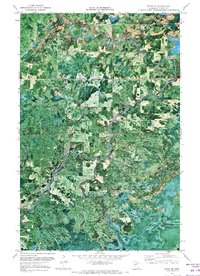 1971 Effie SE1973 Print · USGSNorthern Minnesota's river country is frozen in time just after the turn of the decade. Trace the winding Big Fork River past Muldoon Rapids and Rice Rapids, or follow the Winter Trail through the timberlands.
 - 1971 Map of Effie, 1973 Print
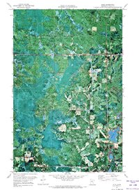 1971 Effie1973 Print · USGSNorth-central Minnesota's logging and lake country comes into focus in the early seventies, centered on the settlement of Effie. Genealogists and historians can trace the paths of Winter Trails and locate local landmarks like Grace Park Ch and Connors Lake.
 - 1976 Map of Bigfork, 1994 Print
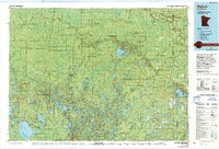 1976 Bigfork1994 Print · USGSNorthern Minnesota's woods and waters are captured in the mid-seventies, showing the intersection of logging country and forest conservation. Researchers can trace rural post offices and fire lookouts like the Scenic Lookout Tower alongside lakes such as Bello Lake and Deer Lake.
End of results
Showing maps 1-3 of 3
Top cities near Effie
Frequently asked questions
- What are the different types of historical maps available for Effie?
- What is the oldest map of Effie?
- Where can I purchase historical maps of Effie for my home or office?
- Where can I download high-res historical maps of Effie?
- Are there historical topographic maps available for Effie?
- Is there historical aerial imagery available for Effie?
- Where are historical maps of Effie sourced from?