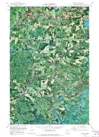
1971 Map of Effie SE
USGS Topo · Published 1973About this map
The Big Fork River carves a winding path through the borderlands of Koochiching and Itasca County, defining the landscape of north-central Minnesota in the early 1970s. This orthophotomap provides a clear view of the river's descent through Muldoon Rapids and Rice Rapids, where the current interacts with the underlying geology. The surrounding terrain is characterized by the Harrington Hills and numerous water bodies including Busties Lake and Grass Lake.
Find a feature on this map
11 named features on this map. Tap any name to fly to it.
Don’t see what you’re looking for? This feature index may not catch every label — zoom into the map to look around manually.
Map Details
Editions of this 1971 Effie SE Map
This is the sole edition of this map. No revisions or reprints were ever made.
Other maps of this area

1919 · Release
USGS Topo · 1:62,500

1919 · Marcell
USGS Topo · 1:62,500

1943 · Release
USGS Topo · 1:62,500

1954 · Hibbing
USGS Topo · 1:250,000

1957 · Hibbing
USGS Topo · 1:250,000

1958 · Hibbing
USGS Topo · 1:250,000

1964 · Hibbing
USGS Topo · 1:250,000

1970 · Coon Lake
USGS Topo · 1:24,000
1970 · Anderson Lake
USGS Topo · 1:24,000
1970 · Deer Lake NW
USGS Topo · 1:24,000