
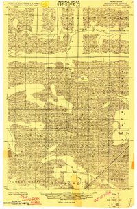
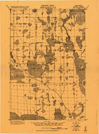
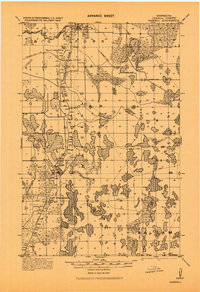
1964 Map of Hibbing
USGS Topo · Published 1964About this map
The Mesabi Range and Vermilion Range anchor this mid-century portrait of Northern Minnesota’s industrial heartland. Dense networks of the Duluth Missabe and Iron Range and the Great Northern railroads weave between mining centers like Hibbing, Virginia, and Chisholm, reflecting an era of intense resource extraction. This landscape is defined by the tension between heavy industry, evidenced by a Tailings pond near the iron formations, and the preserved wilderness of the Chippewa National Forest and Superior National Forest. To the west and south, the Mississippi River and Pokegama Lake provide a sharp contrast to the linear scars of the mining districts. Small communities such as Keewatin, Nashwauk, and Bovey appear alongside the expansive waters of Vermilion Lake and Winnibigoshish Lake, showing the region's dual identity as a timber and ore powerhouse and a premier destination for water-based recreation.
Find a feature on this map
162 named features on this map. Tap any name to fly to it.
Don’t see what you’re looking for? This feature index may not catch every label — zoom into the map to look around manually.
Map Details
Editions of this 1964 Hibbing Map
This is the sole edition of this map. No revisions or reprints were ever made.
Other maps of this area

1895 · Duluth
USGS Topo · 1:62,500

1918 · Zora
USGS Topo · 1:62,500

1919 · Zora
USGS Topo · 1:62,500
1919 · Lundgren
USGS Topo · 1:62,500

1919 · Gemmell
USGS Topo · 1:62,500
1919 · Max
USGS Topo · 1:62,500

1919 · Release
USGS Topo · 1:62,500
1919 · Marcell
USGS Topo · 1:62,500

1919 · M
USGS Topo · 1:62,500

1919 · Margie
USGS Topo · 1:62,500