
1919 Map of Release
USGS Topo · Published 1919About this map
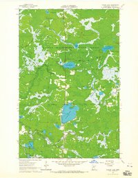
The Prairie River basin in northern Minnesota's lake country defines this 1919 landscape, compiled by the Corps of Engineers, U.S. Army as a military survey. The area is dominated by an intricate network of waterways, including the sprawling Balsam Lake and the unusually named Brush Shanty Lake. Cultural development is sparse, centered on the Release School near the banks of Balsam Creek. The map provides a detailed view of the region before significant modern development, showing the transition from the Long Lakes through Round Lake into the broader river system. Names like Thoreau Lake and Raddison Lake appear alongside local identifiers such as Hunters Lake and Wolf Lake, reflecting a mix of literary and descriptive naming conventions common in early twentieth-century Minnesota.
Find a feature on this map
34 named features on this map. Tap any name to fly to it.
Don’t see what you’re looking for? This feature index may not catch every label — zoom into the map to look around manually.
Map Details
Editions of this 1919 Release Map
This is the sole edition of this map. No revisions or reprints were ever made.
Other maps of this area

1919 · Marcell
USGS Topo · 1:62,500

1920 · Trout Lake
USGS Topo · 1:62,500

1943 · Release
USGS Topo · 1:62,500

1952 · Nashwauk
USGS Topo · 1:24,000

1954 · Hibbing
USGS Topo · 1:250,000

1957 · Hibbing
USGS Topo · 1:250,000

1958 · Hibbing
USGS Topo · 1:250,000

1964 · Hibbing
USGS Topo · 1:250,000

1964 · Sherry Lake
USGS Topo · 1:24,000
1964 · O'Leary Lake
USGS Topo · 1:24,000