1970s Maps of Jackson County, Minnesota
Explore 15 historic maps of Jackson County from the 1970s. These maps offer a rare glimpse into what life looked like during the 1970s — showing old roads, neighborhoods, homes, and landmarks that have changed or disappeared over time.
Whether you're researching your family's past, planning a metal detecting trip, or studying how Jackson County's landscape evolved across the 1970s, these high-resolution maps are a powerful tool for exploring the history of this region.
- Focus on a specific era: All maps on this page are from the 1970s, giving you a focused view of this time period.
- See what’s changed: Compare century-old streets, trails, and buildings to today's modern landscape using overlays and satellite layers.
- Research with precision: Use these maps for genealogy, historical research, land use analysis, or educational projects.
- View, download, or print: Maps are fully viewable online in high resolution, and can be downloaded or printed for your own records.
Start exploring Jackson County's history through authentic maps from the 1970s. This is your window into the past.
Jackson County, MN maps
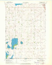
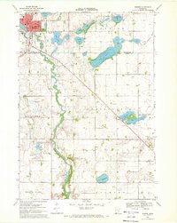
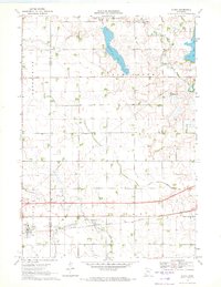
(15)- 1970 Map of Jackson NW, 1972 Print
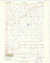 1970 Jackson NW1972 Print · USGSJackson and its surrounding townships are captured here during a period of agricultural and infrastructure expansion in the early seventies. Genealogists and local historians can trace family land in Enterprise, locate the Mennonite Ch, or survey the early grounds of the Jackson Municipal Airport.
 - 1970 Map of Lakefield SW, 1972 Print
 1970 Lakefield SW1972 Print · USGSThe Minnesota-Iowa borderlands come to life in this early 1970s survey, showing a landscape of sprawling wildlife areas and prairie wetlands. Genealogists and local historians can locate Holy Trinity Cem and St Johns Ch or trace the winding Little Sioux River and Sangle Slough.
 - 1970 Map of Lakefield NE, 1972 Print
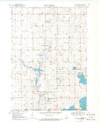
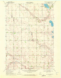
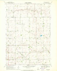
 1970 Lakefield NE1972 Print · USGSJackson County's rural landscape is captured here in the early seventies, dominated by the winding Des Moines River valley. Genealogists can locate family landmarks like Belmont Ch and the East Belmont Cem near the Chicago Milwaukee St Paul and Pacific rail line.2 unique versions available
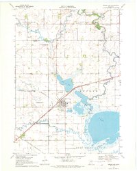
 - 1970 Map of Jackson, 1972 Print
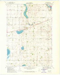
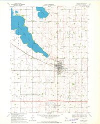
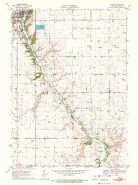 1970 Jackson1972 Print · USGSJackson and the Des Moines River valley appear here in the early seventies as the region balanced its role as a county seat with a river-based economy. Researchers can locate several family burial sites including Riverside and Petersburg Cem, alongside local landmarks like the Powerplant and Getty Park.
 - 1970 Map of Dundee, 1972 Print
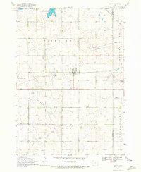
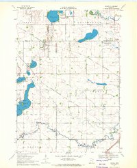 1970 Dundee1972 Print · USGSDundee and Kinbrae thrive at the junction of two major rail lines in this early 1970s landscape of the Minnesota prairie. Genealogists and local historians can trace family ties at St Marys Cemetery or Kinbrae Cemetery and explore the early wildlife management areas surrounding Talcot Lake and Graham Lake.2 unique versions available
 - 1970 Map of Mountain Lake SE, 1972 Print
 1970 Mountain Lake SE1972 Print · USGSSouthern Minnesota farm country is captured here in the early seventies as a network of creek-fed townships across four county lines. Genealogists and local historians can trace legacy landmarks like St Olaf Ch Cem, Cedar Hill Cem, and the waters of Fish Lake.
 - 1970 Map of Wilder, 1972 Print
 1970 Wilder1972 Print · USGSSouthern Minnesota's agricultural prairie and rail-connected towns are captured here in the early 1970s. Researchers can trace the path of the Chicago and North Western railroad or locate rural landmarks like St Peter Ch and Delafield Cem.
 - 1970 Map of Lakefield SE, 1972 Print
 1970 Lakefield SE1972 Print · USGSThe Minnesota-Iowa borderlands appear here in the early seventies, dominated by the drainage networks of the Des Moines River valley. Genealogists and local historians can trace the early layout of Jackson, locate the Vocational Sch, and find the rural Townhall in Middletown.
 - 1970 Map of Lakefield, 1972 Print
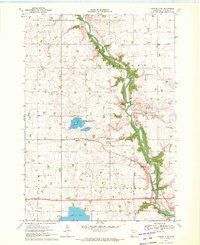
 1970 Lakefield1972 Print · USGSLakefield and the surrounding Jackson County wetlands are documented here in the early 1970s. Trace local roots and rail history through the town's grid, Immanuel Cemetery, and the Chicago Milwaukee St Paul and Pacific line.3 unique versions available
 - 1970 Map of Windom, 1972 Print
 1970 Windom1972 Print · USGSWindom and the surrounding Cottonwood and Jackson County prairies are shown in the early seventies as a thriving rail and river hub. Local historians can trace school sites like Winfair Sch, the grounds of Lakeview Cemetery, and the path of the Chicago and North Western line.
 - 1970 Map of Bergen, 1972 Print
 1970 Bergen1972 Print · USGSSouthern Minnesota farmland is captured here in the early seventies, showing a landscape defined by township grids and river forks. Genealogists and local historians can locate Bergen, the Hauger Cem, and the community Townhall among the sections of Kimball and Belmont.
 - 1970 Map of Dunnell, 1972 Print
 1970 Dunnell1972 Print · USGSDunnell and the surrounding farmlands of Martin and Emmet counties are captured here in the early 1970s. Researchers can trace family ties through the Lake Fremont Cem, the Chicago and North Western rail corridor, and the grid of Judicial Ditch No 105.
 - 1970 Map of Harris, 1972 Print
 1970 Harris1972 Print · USGSOsceola County farmland is captured here in the early 1970s, centered on the railroad town of Harris. Genealogists and local historians can trace the paths of the Chicago Rock Island and Pacific or locate rural burials at Fairview Cem and Union Cem.
 - 1970 Map of Alpha, 1972 Print
 1970 Alpha1972 Print · USGSThe village of Alpha and its surrounding prairie landscape are captured here in the early 1970s, showcasing a rural economy built on rail and water management. Researchers can trace the Chicago Milwaukee St Paul and Pacific line and family-scale operations like the numerous Gravel Pits near Watkins Lake.
 - 1970 Map of Heron Lake, 1972 Print
 1970 Heron Lake1972 Print · USGSJackson County during the early seventies serves as a snapshot of a busy prairie rail hub and its wetland conservation areas. Researchers can trace the junction of the Chicago and North Western in Heron Lake or locate family sites at Sacred Heart Cem and Springfield Cem.
End of results
Showing maps 1-15 of 15
Top cities of Jackson County
- Jackson historical maps
- Lakefield historical maps
- Heron Lake historical maps
- Sioux Valley historical maps
- Petersburg historical maps
- Rost historical maps
See more
Frequently asked questions
- What are the different types of historical maps available for Jackson County?
- What is the oldest map of Jackson County?
- Where can I purchase historical maps of Jackson County for my home or office?
- Where can I download high-res historical maps of Jackson County?
- Are there historical topographic maps available for Jackson County?
- Is there historical aerial imagery available for Jackson County?
- Where are historical maps of Jackson County sourced from?